Photo Mug > Europe > United Kingdom > Scotland > Aberdeenshire > Aberdeen
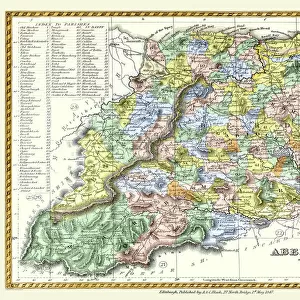
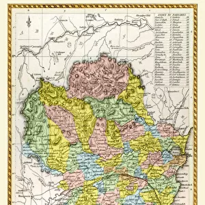
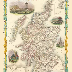
Photo Mug : Old Map of the County of Aberdeen from the Philips Handy Atlas of 1882


![]()
Home Decor from MapSeeker
Old Map of the County of Aberdeen from the Philips Handy Atlas of 1882
PHA002
Welcome to the Mapseeker Image library and enter an historic gateway to one of the largest on-line collections of Historic Maps, Nostalgic Views, Vista's and Panorama's from a World gone by.
Media ID 20347293
County Map County Map Of Scotland Historic Map Old County Map Old Scottish County Map Scottish County Map Aberdeen Aberdeenshire
Photo Mug
Add a touch of history to your daily routine with the Media Storehouse Old Map Mug featuring an intricately detailed image of an Old Map of Aberdeen County from the Philips Handy Atlas of 1882, sourced from MapSeeker. Each mug holds your favorite beverage in high style, making it a unique and thoughtful gift for history enthusiasts or anyone who appreciates the beauty of vintage maps. Embrace the past, one sip at a time.
A personalised photo mug blends sentimentality with functionality, making an ideal gift for cherished loved ones, close friends, or valued colleagues. Preview may show both sides of the same mug.
Elevate your coffee or tea experience with our premium white ceramic mug. Its wide, comfortable handle makes drinking easy, and you can rely on it to be both microwave and dishwasher safe. Sold in single units, preview may show both sides of the same mug so you can see how the picture wraps around.
Mug Size is 8.1cm high x 9.6cm diameter (3.2" x 3.8")
These are individually made so all sizes are approximate
FEATURES IN THESE COLLECTIONS
> MapSeeker
> Maps from the British Isles
> Scotland and Counties PORTFOLIO
> Europe
> United Kingdom
> Scotland
> Aberdeen
> Europe
> United Kingdom
> Scotland
> Aberdeenshire
> Aberdeen
> Europe
> United Kingdom
> Scotland
> Aberdeenshire
> Related Images
> Europe
> United Kingdom
> Scotland
> Maps
> Europe
> United Kingdom
> Scotland
> Posters
> Europe
> United Kingdom
> Scotland
> Related Images
> Maps and Charts
> Early Maps
> Maps and Charts
> Related Images
EDITORS COMMENTS
This print showcases an exquisite piece of history, the "Old Map of the County of Aberdeen from the Philips Handy Atlas of 1882". Steeped in Scottish heritage, this vintage map offers a fascinating glimpse into the past. With its intricate details and rich colors, it transports us back to a time when cartography was both an art form and a vital tool for exploration. The map encompasses not only Aberdeen but also Aberdeenshire, providing valuable insights into these regions' historical significance. It reveals the county's diverse landscapes, from rolling hills to winding rivers and charming coastal towns. Every contour line tells a story, inviting us to imagine how life must have unfolded in this enchanting part of Scotland over a century ago. As we study this historic gem, we can't help but marvel at its meticulous craftsmanship. The careful placement of cities and villages highlights their importance within the county's fabric. This visual treasure trove serves as more than just a geographical reference; it is an invaluable portal into our ancestors' world. Whether you are an avid historian or simply captivated by Scotland's allure, this old Scottish county map is sure to ignite your imagination. Display it proudly on your wall or use it as inspiration for further exploration – let its timeless charm transport you through time and space.
MADE IN AUSTRALIA
Safe Shipping with 30 Day Money Back Guarantee
FREE PERSONALISATION*
We are proud to offer a range of customisation features including Personalised Captions, Color Filters and Picture Zoom Tools
SECURE PAYMENTS
We happily accept a wide range of payment options so you can pay for the things you need in the way that is most convenient for you
* Options may vary by product and licensing agreement. Zoomed Pictures can be adjusted in the Cart.