Photo Mug > Maps and Charts > Early Maps
Photo Mug : Description de la Terre Universelle (1667). Map
. Map")
. Map")

![]()
Home Decor from Mary Evans Picture Library
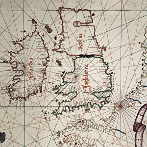
Description de la Terre Universelle (1667). Map
Description de la Terre Universelle (1667). Map. Engraving
Mary Evans Picture Library makes available wonderful images created for people to enjoy over the centuries
Media ID 8272173
© Mary Evans Picture Library 2015 - https://copyrighthub.org/s0/hub1/creation/maryevans/MaryEvansPictureID/10685826
Alpha Cartographic Cartographies Cartography Description Earth Engravings Equator Equatorial Maps Navigation Omega Sail Terre Terrestrial Universelle
Photo Mug
Introducing our Media Storehouse Photo Mugs, the perfect blend of history and functionality. This unique mug features an exquisite engraving of "Description de la Terre Universelle (1667). Map" by Rights Managed from Mary Evans Prints Online. Travel back in time with this intricately detailed, vintage map design that adorns the exterior of your mug. Each sip brings a new adventure as you explore the wonders of the world's past. Embrace the fusion of history and modern convenience with our high-quality, microwave and dishwasher safe Photo Mugs. Make your daily routine a little more interesting with this captivating, one-of-a-kind mug.
A personalised photo mug blends sentimentality with functionality, making an ideal gift for cherished loved ones, close friends, or valued colleagues. Preview may show both sides of the same mug.
Elevate your coffee or tea experience with our premium white ceramic mug. Its wide, comfortable handle makes drinking easy, and you can rely on it to be both microwave and dishwasher safe. Sold in single units, preview may show both sides of the same mug so you can see how the picture wraps around.
Mug Size is 8.1cm high x 9.6cm diameter (3.2" x 3.8")
These are individually made so all sizes are approximate
FEATURES IN THESE COLLECTIONS
> Maps and Charts
> Early Maps
> Maps and Charts
> Related Images
EDITORS COMMENTS
This stunning engraving is a captivating glimpse into the historical world of cartography during the 17th century. The "Description de la Terre Universelle" or "Description of the Universal Earth," created in 1667, is a remarkable example of early terrestrial mapping. The map's title, written in elegant script, is situated at the top, with the equator and meridian lines clearly marked, dividing the map into quadrants. The map's horizontal orientation, a departure from the traditional vertical format, reflects the growing influence of the nautical community in cartography. The map's intricate detailing showcases the known world as it was understood during that time, with accurate depictions of continents, islands, and major bodies of water. The map's color palette, while not vibrant by today's standards, would have been a significant improvement over the monochrome maps of the past. The map's border is adorned with various decorative elements, including intricate engravings of sailing ships and the Greek letters Alpha and Omega, symbolizing the beginning and end of the world. The map's creation was a testament to the advancements in navigation and cartography during the Age of Exploration. It served as a valuable tool for navigators and explorers, helping them to chart their courses and expand the boundaries of human knowledge. Today, this engraving stands as a reminder of the rich history of cartography and the enduring allure of the world's vast and mysterious landscapes.
MADE IN AUSTRALIA
Safe Shipping with 30 Day Money Back Guarantee
FREE PERSONALISATION*
We are proud to offer a range of customisation features including Personalised Captions, Color Filters and Picture Zoom Tools
SECURE PAYMENTS
We happily accept a wide range of payment options so you can pay for the things you need in the way that is most convenient for you
* Options may vary by product and licensing agreement. Zoomed Pictures can be adjusted in the Cart.