Poster Print > Maps and Charts > Related Images
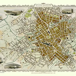
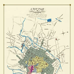
Poster Print : Old Map of Birmingham 1816


![]()
Poster Prints from MapSeeker
Old Map of Birmingham 1816
J077
Welcome to the Mapseeker Image library and enter an historic gateway to one of the largest on-line collections of Historic Maps, Nostalgic Views, Vista's and Panorama's from a World gone by.
Media ID 20347144
Birmingham Birmingham City Birmingham City Map Birmingham Map Birmingham Town Plan City Of Birmingham Map Historic Birmingham Map Historic Map Map Of Birmingham Old Map Of Birmingham Old Town Plan Town Plan Of Birmingham
A4 (29.7 x 21cm) Poster Print
Premium quality poster prints are printed on luxurious semi-gloss satin 270 gsm paper. Our meticulously crafted poster prints offer an affordable option for decorating any space, making them ideal for living rooms, bedrooms, offices and beyond. To ensure your poster arrives in good condition, we roll and send them in strong mailing tubes.
Poster prints are budget friendly enlarged prints in standard poster paper sizes (A0, A1, A2, A3 etc). Whilst poster paper is sometimes thinner and less durable than our other paper types, they are still ok for framing and should last many years. Our Archival Quality Photo Prints and Fine Art Paper Prints are printed on higher quality paper and the choice of which largely depends on your budget.
Estimated Product Size is 21.6cm x 30.3cm (8.5" x 11.9")
These are individually made so all sizes are approximate
Artwork printed orientated as per the preview above, with portrait (vertical) orientation to match the source image.
FEATURES IN THESE COLLECTIONS
> MapSeeker
> British Town And City Plans
> English & Welsh PORTFOLIO
> Maps and Charts
> Related Images
EDITORS COMMENTS
This print showcases an exquisite piece of history, the "Old Map of Birmingham 1816 (J077)". Steeped in nostalgia and charm, this map takes us on a journey back in time to witness the birth of a vibrant city. With intricate details and delicate craftsmanship, it offers an invaluable glimpse into the past. Dating back to 1816, this historic map unveils the early layout and development of Birmingham. Every street, alleyway, and landmark is meticulously depicted, allowing us to trace its evolution from a humble town to a bustling metropolis. The town plan reveals how Birmingham's urban landscape has transformed over centuries. As we explore this remarkable artifact further, we are transported to an era where horse-drawn carriages roamed these streets and grand Victorian buildings adorned the skyline. It serves as a testament to the resilience and progress that have shaped Birmingham into what it is today. Whether you are an avid historian or simply captivated by maps' allure, this print is sure to be a cherished addition for any collector or enthusiast. Its timeless beauty invites us not only to admire but also reflect upon our own place within history's tapestry
MADE IN AUSTRALIA
Safe Shipping with 30 Day Money Back Guarantee
FREE PERSONALISATION*
We are proud to offer a range of customisation features including Personalised Captions, Color Filters and Picture Zoom Tools
SECURE PAYMENTS
We happily accept a wide range of payment options so you can pay for the things you need in the way that is most convenient for you
* Options may vary by product and licensing agreement. Zoomed Pictures can be adjusted in the Cart.