Home > Europe > France > Canton > Landes
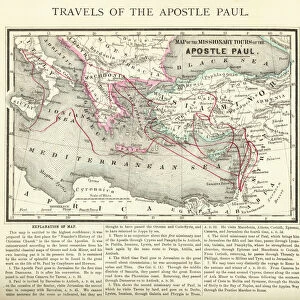
1865 Spruner Map Of Greece Macedonia And Thrace Before The Peloponnesian War

![]()
Wall Art and Photo Gifts from Universal Images Group (UIG)
1865 Spruner Map Of Greece Macedonia And Thrace Before The Peloponnesian War
1865, Spruner Map of Greece, Macedonia and Thrace before the Peloponnesian War
Universal Images Group (UIG) manages distribution for many leading specialist agencies worldwide
Media ID 38549556
© Artokoloro Quint Lox Limited
1865 Antique Map Latitude Longitude Mappa Mundi Old Antique Plan Old Antique View Ols Antique Map Rare Old Maps Topo
FEATURES IN THESE COLLECTIONS
> Europe
> France
> Canton
> Landes
> Europe
> Greece
> Related Images
> Europe
> Macedonia
> Related Images
> Historic
> Ancient civilizations
> Ancient Greece
> Greek history
> Historic
> Space exploration
> Maps and Charts
> Early Maps
> Maps and Charts
> North Macedonia
> Universal Images Group (UIG)
> History
> Historical Maps
EDITORS COMMENTS
Step back in time to ancient Greece with this stunning 1865 Spruner Map of Greece, Macedonia and Thrace before the Peloponnesian War. This beautifully illustrated map provides a fascinating glimpse into the geography and topography of the region during a pivotal moment in history.
Created by German cartographer Karl von Spruner, this map showcases the intricate details of the landscape, featuring mountains, rivers, cities, and roads that crisscrossed ancient Greece. The Peloponnesian War was a devastating conflict between Athens and Sparta that lasted from 431-404 BCE, shaping the course of Greek history forever.
This vintage map is not only a work of art but also a valuable resource for historians and enthusiasts alike. It offers a unique perspective on the region's geography, highlighting key features such as Mount Olympus, Lake Stymphalia, and the River Aliakmon.
The level of detail on this map is remarkable, with illustrations of buildings, fortifications, and even mythical creatures like dragons adorning its borders. The use of color adds an extra layer of depth and visual interest to this already captivating image.
Whether you're an historian seeking insight into ancient civilizations or simply someone who appreciates beautiful maps as works of art, this 1865 Spruner Map is sure to captivate.
MADE IN AUSTRALIA
Safe Shipping with 30 Day Money Back Guarantee
FREE PERSONALISATION*
We are proud to offer a range of customisation features including Personalised Captions, Color Filters and Picture Zoom Tools
SECURE PAYMENTS
We happily accept a wide range of payment options so you can pay for the things you need in the way that is most convenient for you
* Options may vary by product and licensing agreement. Zoomed Pictures can be adjusted in the Cart.