Canvas Print > Arts > Artists > B > Willem Blaeu
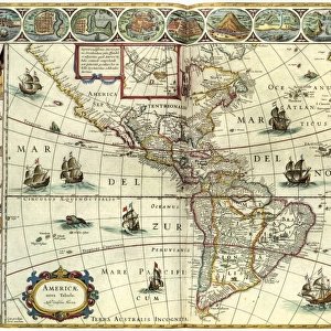
Canvas Print : WORLD MAP, 1635. By Willem Janszoon Blaeu, with two polar insets in the body of the map


![]()
Canvas Prints from Granger
WORLD MAP, 1635. By Willem Janszoon Blaeu, with two polar insets in the body of the map
WORLD MAP, 1635. By Willem Janszoon Blaeu, with two polar insets in the body of the map and border panels depicting the four elements, the seven known planets, the four seasons, and the seven wonders of the world
Granger holds millions of images spanning more than 25,000 years of world history, from before the Stone Age to the dawn of the Space Age
Media ID 6622159
1635 Blaeu Janszoon Pole Season Seven Wonders Of The World Willem World
20"x16" (51x41cm) Canvas Print
"Discover the wonders of the world past with our stunning Canvas Print of the 1635 Willem Janszoon Blaeu World Map from The Granger Collection. This captivating piece transports you back in time with intricate detailing of continents, seas, and two polar insets. Delight in the border panels that depict the four elements, the seven known planets, and the four seasons, adding an extra layer of intrigue. Bring history into your home with this beautiful and educational canvas print."
Delivered stretched and ready to hang our premium quality canvas prints are made from a polyester/cotton blend canvas and stretched over a 1.25" (32mm) kiln dried knot free wood stretcher bar. Packaged in a plastic bag and secured to a cardboard insert for safe transit.
Canvas Prints add colour, depth and texture to any space. Professionally Stretched Canvas over a hidden Wooden Box Frame and Ready to Hang
Estimated Product Size is 50.8cm x 40.6cm (20" x 16")
These are individually made so all sizes are approximate
Artwork printed orientated as per the preview above, with landscape (horizontal) orientation to match the source image.
FEATURES IN THESE COLLECTIONS
> Arts
> Artists
> B
> Willem Blaeu
> Arts
> Landscape paintings
> Waterfall and river artworks
> River artworks
> Maps and Charts
> Early Maps
> Maps and Charts
> Related Images
> Maps and Charts
> Willem Janszoon Blaeu
> Maps and Charts
> World
> Granger Art on Demand
> Maps
EDITORS COMMENTS
This print showcases the remarkable "World Map, 1635" by Willem Janszoon Blaeu. A true masterpiece of cartography, this map takes us back to an early era where exploration and discovery were at their peak. The intricate details and exquisite craftsmanship are evident in every inch of this stunning piece. The map itself is adorned with two polar insets, providing a unique perspective on the world's geography. Surrounding the main body of the map are border panels that depict various elements such as the four seasons, the seven known planets, and even the awe-inspiring seven wonders of the world. These additions not only enhance its visual appeal but also offer a glimpse into ancient beliefs and knowledge. Willem Janszoon Blaeu's expertise shines through in his meticulous rendering of rivers, coastlines, and continents across this vast canvas. It serves as a testament to his dedication to accuracy and precision during an era when mapping was still evolving. As we gaze upon this extraordinary artwork from The Granger Collection, we can't help but be transported back in time to an age filled with curiosity and wonderment. This print allows us to appreciate both the historical significance and artistic brilliance encapsulated within "World Map, 1635. "
MADE IN AUSTRALIA
Safe Shipping with 30 Day Money Back Guarantee
FREE PERSONALISATION*
We are proud to offer a range of customisation features including Personalised Captions, Color Filters and Picture Zoom Tools
SECURE PAYMENTS
We happily accept a wide range of payment options so you can pay for the things you need in the way that is most convenient for you
* Options may vary by product and licensing agreement. Zoomed Pictures can be adjusted in the Cart.