Canvas Print > Arts > Artists > B > Joan Blaeu
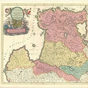
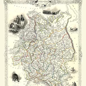
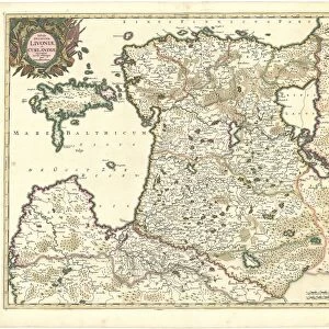
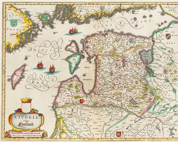
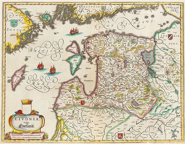
Canvas Print : Livonia Map, Vulgo Lyefland, Atlas Maior. Artist: Blaeu, Joan (1596-1673)
")
")

![]()
Canvas Prints from Heritage Images
Livonia Map, Vulgo Lyefland, Atlas Maior. Artist: Blaeu, Joan (1596-1673)
Livonia Map, Vulgo Lyefland, Atlas Maior. Private Collection
Heritage Images features heritage image collections
Media ID 15017212
© Fine Art Images
Baltic Sea Blaeu Cartography Courland Livonia The Netherlands Atlas Maior Sea Map
20"x16" (51x41cm) Canvas Print
Discover the captivating detail of the past with our Media Storehouse Canvas Print of the Livonia Map, Vulgo Lyefland, from Atlas Maior. This exquisite piece, featuring the intricate cartography of Joan Blaeu (1596-1673), showcases the historical Livonian region as it appeared in the 17th century. Bring the rich heritage of this rare map into your home or office, expertly reproduced on high-quality canvas for a stunning, gallery-worthy display. A true conversation starter and a beautiful addition to any space.
Delivered stretched and ready to hang our premium quality canvas prints are made from a polyester/cotton blend canvas and stretched over a 1.25" (32mm) kiln dried knot free wood stretcher bar. Packaged in a plastic bag and secured to a cardboard insert for safe transit.
Canvas Prints add colour, depth and texture to any space. Professionally Stretched Canvas over a hidden Wooden Box Frame and Ready to Hang
Estimated Product Size is 50.8cm x 40.6cm (20" x 16")
These are individually made so all sizes are approximate
Artwork printed orientated as per the preview above, with landscape (horizontal) orientation to match the source image.
FEATURES IN THESE COLLECTIONS
> Arts
> Artists
> B
> Joan Blaeu
> Europe
> Netherlands
> Maps
> Europe
> Netherlands
> Posters
> Europe
> Netherlands
> Related Images
> Maps and Charts
> Netherlands
> Maps and Charts
> Related Images
EDITORS COMMENTS
This print showcases the historical Livonia Map, also known as Vulgo Lyefland, from the renowned Atlas Maior collection. Created by the talented artist Joan Blaeu (1596-1673), this map offers a fascinating glimpse into the past. The intricate details and vibrant colors of this etching and watercolor masterpiece bring to life the Baltic Sea region, including Livonia, Courland, and surrounding areas. It is a testament to Blaeu's exceptional cartography skills and his dedication to accurately representing geographical features. As we admire this private collection piece, we are transported back in time to an era when maps were not only navigational tools but also works of art. The Livonia Map provides valuable insights into the history of these regions while showcasing their importance during that period. With its rich maritime heritage depicted through sea routes and coastal towns, this map serves as a visual reminder of how vital trade was for nations like The Netherlands. Its inclusion in Atlas Maior further emphasizes its significance within cartographic circles. This print captures every intricate detail with precision and clarity, allowing us to appreciate both its artistic beauty and historical value. Whether you are an avid collector or simply fascinated by fine art images depicting our world's history, this Livonia Map will undoubtedly be a treasured addition to any collection - all without mentioning commercial use!
MADE IN AUSTRALIA
Safe Shipping with 30 Day Money Back Guarantee
FREE PERSONALISATION*
We are proud to offer a range of customisation features including Personalised Captions, Color Filters and Picture Zoom Tools
SECURE PAYMENTS
We happily accept a wide range of payment options so you can pay for the things you need in the way that is most convenient for you
* Options may vary by product and licensing agreement. Zoomed Pictures can be adjusted in the Cart.