Canvas Print > Europe > United Kingdom > England > London > Towns > Welling
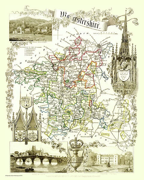
Canvas Print : Old County Map of Worcestershire 1836 by Thomas Moule
![]()

Canvas Prints from MapSeeker
Old County Map of Worcestershire 1836 by Thomas Moule
This is a fine decorative reproduction County Map of Worcestershire from the First Edition series of Thomas Moule Maps, originally Published in 1836. The well-known series of County Maps which are known as Moules feature beautiful vignette views and were first published in separate sections for each county in 1830-32, they were then published in collected form in a two-volume work: The English Counties Delineated: or a Topographical Description of England: Illustrated by a Complete Series of County Maps by Thomas Moule: London: Published by George Virtue 1836
Welcome to the Mapseeker Image library and enter an historic gateway to one of the largest on-line collections of Historic Maps, Nostalgic Views, Vista's and Panorama's from a World gone by.
Media ID 20347913
© Mapseeker Publishing Ltd
County Map County Map Of England English County Map Historic Map Moule Map Old County Map Old English County Map Old Moule Map Thomas Moule Thomas Moule Map Worcestershire
20"x16" (51x41cm) Canvas Print
Introducing the Media Storehouse Canvas Print of the Old County Map of Worcestershire, a stunning decor piece for history enthusiasts and map collectors alike. This exquisite reproduction is based on the original 1836 map by Thomas Moule, published in collaboration with George Virtue from MapSeeker. Crafted with meticulous attention to detail, this fine art canvas print showcases the Old County Map of Worcestershire in its entirety, capturing the essence of the historic county's topography and geography. The map is adorned with intricate cartography, including towns, villages, rivers, and roads, all faithfully reproduced from the first edition Thomas Moule Map. The canvas print is a beautiful addition to any room, adding a touch of timeless charm and elegance. Its high-quality, vibrant colors and rich textures bring the map to life, making it a captivating conversation starter and a cherished family heirloom for generations to come. Experience the allure of history with our Media Storehouse Canvas Print of the Old County Map of Worcestershire by Thomas Moule. Order yours today and bring a piece of the past into your home.
Delivered stretched and ready to hang our premium quality canvas prints are made from a polyester/cotton blend canvas and stretched over a 1.25" (32mm) kiln dried knot free wood stretcher bar. Packaged in a plastic bag and secured to a cardboard insert for safe transit.
Canvas Prints add colour, depth and texture to any space. Professionally Stretched Canvas over a hidden Wooden Box Frame and Ready to Hang
Estimated Product Size is 40.6cm x 50.8cm (16" x 20")
These are individually made so all sizes are approximate
Artwork printed orientated as per the preview above, with portrait (vertical) orientation to match the source image.
FEATURES IN THESE COLLECTIONS
> Arts
> Artists
> M
> Thomas Moule
> Europe
> United Kingdom
> England
> London
> Towns
> Welling
> Europe
> United Kingdom
> England
> Maps
> Europe
> United Kingdom
> England
> Wells
> Europe
> United Kingdom
> England
> Worcestershire
> Related Images
> Maps and Charts
> Related Images
> MapSeeker
> Maps from the British Isles
> England and Counties PORTFOLIO
EDITORS COMMENTS
This exquisite print showcases the "Old County Map of Worcestershire 1836" by Thomas Moule, a renowned cartographer of his time. This particular map is part of the esteemed First Edition series of Thomas Moule Maps, originally published in 1836. Moule's County Maps are highly regarded for their intricate details and captivating vignette views. They were initially released as separate sections for each county between 1830 and 1832 before being compiled into a two-volume masterpiece titled "The English Counties Delineated: or a Topographical Description of England: Illustrated by a Complete Series of County Maps". George Virtue was responsible for publishing this remarkable work in London in the year 1836. The historic significance of this old English county map cannot be overstated. It provides an invaluable glimpse into Worcestershire's past, showcasing its geographical features, towns, and landmarks as they existed nearly two centuries ago. The attention to detail and artistic flair with which Moule crafted his maps make them not only informative but also visually stunning works of art. Whether you have an affinity for history or simply appreciate fine decorative reproductions, this print offers a unique opportunity to own a piece from one of Thomas Moule's iconic creations. Display it proudly on your wall and let it transport you back in time to explore the rich heritage and charm that Worcestershire has to offer.
MADE IN AUSTRALIA
Safe Shipping with 30 Day Money Back Guarantee
FREE PERSONALISATION*
We are proud to offer a range of customisation features including Personalised Captions, Color Filters and Picture Zoom Tools
SECURE PAYMENTS
We happily accept a wide range of payment options so you can pay for the things you need in the way that is most convenient for you
* Options may vary by product and licensing agreement. Zoomed Pictures can be adjusted in the Cart.


