Cushion > Europe > France > Canton > Landes
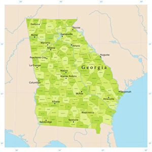
Cushion : 1865 Johnson Map Of Georgia And Alabama Topography


![]()
Home Decor From Universal Images Group (UIG)
1865 Johnson Map Of Georgia And Alabama Topography
1865, Johnson Map of Georgia and Alabama
Universal Images Group (UIG) manages distribution for many leading specialist agencies worldwide
Media ID 38551754
© Artokoloro Quint Lox Limited
1865 Antique Map Latitude Longitude Mappa Mundi Old Antique Plan Old Antique View Ols Antique Map Rare Old Maps Topo
Cushion
Refresh your home decor with a beautiful full photo 16"x16" (40x40cm) cushion, complete with cushion pad insert. Printed on both sides and made from 100% polyester with a zipper on the bottom back edge of the cushion cover. Care Instructions: Warm machine wash, do not bleach, do not tumble dry. Warm iron inside out. Do not dry clean.
Accessorise your space with decorative, soft cushions
Estimated Product Size is 40cm x 40cm (15.7" x 15.7")
These are individually made so all sizes are approximate
Artwork printed orientated as per the preview above, with landscape (horizontal) or portrait (vertical) orientation to match the source image.
FEATURES IN THESE COLLECTIONS
> Animals
> Fishes
> G
> Grouper
> Asia
> Georgia
> Related Images
> Europe
> France
> Canton
> Landes
> Historic
> Space exploration
> Maps and Charts
> Early Maps
> Maps and Charts
> Related Images
> Maps and Charts
> World
EDITORS COMMENTS
Step back in time to the tumultuous year of 1865 with this rare and fascinating print of Johnson's Map of Georgia and Alabama Topography. Created during a pivotal moment in American history, this map provides a unique glimpse into the geography and cartography of the region just after the end of the Civil War.
Produced by A.J. Johnson, a renowned cartographer of his time, this map showcases the topographical features of Georgia and Alabama with remarkable detail. The intricate illustration depicts mountains, rivers, towns, roads, and other geographical landmarks with precision and accuracy.
This vintage map is not only a testament to Johnson's skill as a cartographer but also serves as a window into the past. It offers insight into the region's natural resources, transportation networks, and population centers at a critical juncture in American history.
The aged paper has developed a beautiful patina over time, giving the map an air of nostalgia and historical significance. This stunning piece would be an excellent addition to any collection or display dedicated to geography, history, or vintage maps. Its unique blend of artistry and utility makes it both visually striking and intellectually engaging.
MADE IN AUSTRALIA
Safe Shipping with 30 Day Money Back Guarantee
FREE PERSONALISATION*
We are proud to offer a range of customisation features including Personalised Captions, Color Filters and Picture Zoom Tools
SECURE PAYMENTS
We happily accept a wide range of payment options so you can pay for the things you need in the way that is most convenient for you
* Options may vary by product and licensing agreement. Zoomed Pictures can be adjusted in the Basket.