Photographic Print > Europe > France > Canton > Landes
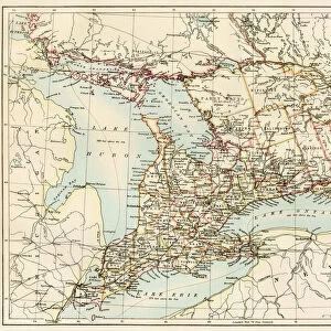
Photographic Print : 1865 Johnson Map Of Georgia And Alabama Topography


![]()
Photo Prints From Universal Images Group (UIG)
1865 Johnson Map Of Georgia And Alabama Topography
1865, Johnson Map of Georgia and Alabama
Universal Images Group (UIG) manages distribution for many leading specialist agencies worldwide
Media ID 38551754
© Artokoloro Quint Lox Limited
1865 Antique Map Latitude Longitude Mappa Mundi Old Antique Plan Old Antique View Ols Antique Map Rare Old Maps Topo
10"x8" (25x20cm) Photo Print
"Step back in time with our stunning Photographic Print from the Media Storehouse range, featuring the iconic 1865 Johnson Map of Georgia and Alabama Topography. This historic map, courtesy of Universal Images Group (UIG), offers a fascinating glimpse into the region's geography during the American Civil War era. Printed on high-quality paper, this photographic print is a must-have for history buffs, collectors, and anyone fascinated by the past. Bring a piece of history to your home or office with this unique and captivating visual artifact."
Ideal for framing, Australian made Photo Prints are produced on high-quality 270 gsm lustre photo paper which has a subtle shimmer adding a touch of elegance, designed to enhance their visual appeal.
Our Photo Prints are in a large range of sizes and are printed on Archival Quality Paper for excellent colour reproduction and longevity. They are ideal for framing (our Framed Prints use these) at a reasonable cost. Alternatives include cheaper Poster Prints and higher quality Fine Art Paper, the choice of which is largely dependant on your budget.
Estimated Image Size (if not cropped) is 25.4cm x 18.5cm (10" x 7.3")
Estimated Product Size is 25.4cm x 20.3cm (10" x 8")
These are individually made so all sizes are approximate
Artwork printed orientated as per the preview above, with landscape (horizontal) orientation to match the source image.
FEATURES IN THESE COLLECTIONS
> Animals
> Fishes
> G
> Grouper
> Asia
> Georgia
> Related Images
> Europe
> France
> Canton
> Landes
> Historic
> Space exploration
> Maps and Charts
> Early Maps
> Maps and Charts
> Related Images
> Maps and Charts
> World
EDITORS COMMENTS
Step back in time to the tumultuous year of 1865 with this rare and fascinating print of Johnson's Map of Georgia and Alabama Topography. Created during a pivotal moment in American history, this map provides a unique glimpse into the geography and cartography of the region just after the end of the Civil War.
Produced by A.J. Johnson, a renowned cartographer of his time, this map showcases the topographical features of Georgia and Alabama with remarkable detail. The intricate illustration depicts mountains, rivers, towns, roads, and other geographical landmarks with precision and accuracy.
This vintage map is not only a testament to Johnson's skill as a cartographer but also serves as a window into the past. It offers insight into the region's natural resources, transportation networks, and population centers at a critical juncture in American history.
The aged paper has developed a beautiful patina over time, giving the map an air of nostalgia and historical significance. This stunning piece would be an excellent addition to any collection or display dedicated to geography, history, or vintage maps. Its unique blend of artistry and utility makes it both visually striking and intellectually engaging.
MADE IN AUSTRALIA
Safe Shipping with 30 Day Money Back Guarantee
FREE PERSONALISATION*
We are proud to offer a range of customisation features including Personalised Captions, Color Filters and Picture Zoom Tools
SECURE PAYMENTS
We happily accept a wide range of payment options so you can pay for the things you need in the way that is most convenient for you
* Options may vary by product and licensing agreement. Zoomed Pictures can be adjusted in the Basket.