Photo Mug > Europe > France > Canton > Landes
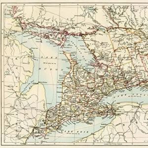
Photo Mug : 1865 Johnson Map Of Georgia And Alabama Topography


![]()
Home Decor From Universal Images Group (UIG)
1865 Johnson Map Of Georgia And Alabama Topography
1865, Johnson Map of Georgia and Alabama
Universal Images Group (UIG) manages distribution for many leading specialist agencies worldwide
Media ID 38551754
© Artokoloro Quint Lox Limited
1865 Antique Map Latitude Longitude Mappa Mundi Old Antique Plan Old Antique View Ols Antique Map Rare Old Maps Topo
Photo Mug
"Add a touch of history to your morning routine with our unique Photo Mugs featuring the 1865 Johnson Map of Georgia and Alabama Topography from Universal Images Group (UIG). This stunning image showcases the topography of these two southern states during the American Civil War era. Perfect for history buffs, geography enthusiasts, or anyone looking to add a vintage touch to their daily coffee ritual. Each mug is carefully crafted with high-quality printing and durable materials, ensuring it will withstand multiple uses and washes. Make every sip feel like a step back in time!"
A personalised photo mug blends sentimentality with functionality, making an ideal gift for cherished loved ones, close friends, or valued colleagues. Preview may show both sides of the same mug.
Elevate your coffee or tea experience with our premium white ceramic mug. Its wide, comfortable handle makes drinking easy, and you can rely on it to be both microwave and dishwasher safe. Sold in single units, preview may show both sides of the same mug so you can see how the picture wraps around.
Mug Size is 8.1cm high x 9.6cm diameter (3.2" x 3.8")
These are individually made so all sizes are approximate
FEATURES IN THESE COLLECTIONS
> Animals
> Fishes
> G
> Grouper
> Asia
> Georgia
> Related Images
> Europe
> France
> Canton
> Landes
> Historic
> Space exploration
> Maps and Charts
> Early Maps
> Maps and Charts
> Related Images
> Maps and Charts
> World
EDITORS COMMENTS
Step back in time to the tumultuous year of 1865 with this rare and fascinating print of Johnson's Map of Georgia and Alabama Topography. Created during a pivotal moment in American history, this map provides a unique glimpse into the geography and cartography of the region just after the end of the Civil War.
Produced by A.J. Johnson, a renowned cartographer of his time, this map showcases the topographical features of Georgia and Alabama with remarkable detail. The intricate illustration depicts mountains, rivers, towns, roads, and other geographical landmarks with precision and accuracy.
This vintage map is not only a testament to Johnson's skill as a cartographer but also serves as a window into the past. It offers insight into the region's natural resources, transportation networks, and population centers at a critical juncture in American history.
The aged paper has developed a beautiful patina over time, giving the map an air of nostalgia and historical significance. This stunning piece would be an excellent addition to any collection or display dedicated to geography, history, or vintage maps. Its unique blend of artistry and utility makes it both visually striking and intellectually engaging.
MADE IN AUSTRALIA
Safe Shipping with 30 Day Money Back Guarantee
FREE PERSONALISATION*
We are proud to offer a range of customisation features including Personalised Captions, Color Filters and Picture Zoom Tools
SECURE PAYMENTS
We happily accept a wide range of payment options so you can pay for the things you need in the way that is most convenient for you
* Options may vary by product and licensing agreement. Zoomed Pictures can be adjusted in the Basket.