Home > Aerial Photography > Iceland
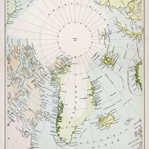
Europe At Night, True Colour Satellite Image. True colour satellite image of Europe at night. This image in Lambert Conformal Conic projection was compiled from data acquired by LANDSAT 5 & 7 satellites

![]()
Wall Art and Photo Gifts from Design Pics
Europe At Night, True Colour Satellite Image. True colour satellite image of Europe at night. This image in Lambert Conformal Conic projection was compiled from data acquired by LANDSAT 5 & 7 satellites
Design Pics offers Distinctively Different Imagery representing over 1,500 contributors
Media ID 24589203
© UIG / Design Pics
Aerial Alps Atlantic Ocean Baltic Sea Carpathians Continent Earth Earth Science Environment Geographic Illustration Greenland Iceland Mediterranean Sea Night North Sea Planet Planet Earth Pyrenees Relief Satellite Satellite Image Sciences Space Uig Premium 1 Uig1 Satellite And Aerial Black Sea Nort
FEATURES IN THESE COLLECTIONS
> Aerial Photography
> Iceland
> Aerial Photography
> Related Images
> Arts
> Artists
> O
> Oceanic Oceanic
> Design Pics
> Design Pics Art
> Design Pics
> Universal Images Group
> Design Pics
> Update - March 23, 2022
> Europe
> Iceland
> Related Images
> Maps and Charts
> Related Images
> North America
> Greenland
> Maps
> North America
> Greenland
> Related Images
EDITORS COMMENTS
This print showcases the mesmerizing beauty of Europe at night, captured in a true color satellite image. The image, presented in Lambert Conformal Conic projection, is a compilation of data acquired by LANDSAT 5 & 7 satellites. From the vibrant lights that illuminate major cities to the serene darkness enveloping vast landscapes, this illustration offers a unique perspective on our planet Earth. The continent of Europe is depicted with remarkable detail and accuracy, revealing its diverse topography and geographical features. As your eyes wander across this image, you can trace the majestic Pyrenees and Alps mountain ranges cutting through the continent. The stunning island nation of Iceland shines brightly amidst the surrounding Atlantic Ocean. From there, your gaze sweeps over various bodies of water including the North Sea, Mediterranean Sea, Baltic Sea, and Black Sea. The relief map highlights prominent landmarks such as Greenland's icy expanse and the Carpathian Mountains. This breathtaking snapshot not only captures Europe's urban sprawl but also emphasizes its harmonious coexistence with nature. Whether you are an enthusiast in space exploration or simply appreciate our planet's natural wonders from above, this satellite image serves as a reminder of both human impact on Earth and its enduring beauty.
MADE IN AUSTRALIA
Safe Shipping with 30 Day Money Back Guarantee
FREE PERSONALISATION*
We are proud to offer a range of customisation features including Personalised Captions, Color Filters and Picture Zoom Tools
SECURE PAYMENTS
We happily accept a wide range of payment options so you can pay for the things you need in the way that is most convenient for you
* Options may vary by product and licensing agreement. Zoomed Pictures can be adjusted in the Cart.