Home > Asia > China > Maps
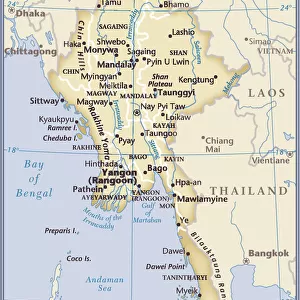
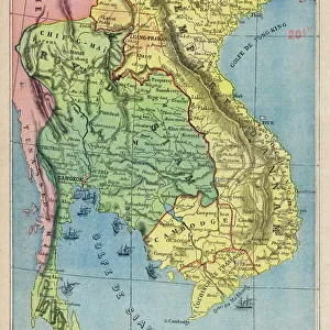
Map of Eastern India, c.1900 (engraving)
")
![]()
Wall Art and Photo Gifts from Fine Art Finder
Map of Eastern India, c.1900 (engraving)
533022 Map of Eastern India, c.1900 (engraving); (add.info.: Map showing historical boundaries of eastern India, Burma, Siam and French Indo-China, circa 1902, from the 10th edition of Encyclopaedia Britannica.); Encyclopaedia Britannica/UIG
Media ID 38208566
© Encyclopaedia Britannica/UIG / Bridgeman Images
1902 19th Century Style Boundary Burma Cartography Geographical Border Guidance Illustration Technique Indo China Meridian Navigational Equipment Old Fashioned Part Of Physical Geography Siam The Past Western Script
FEATURES IN THESE COLLECTIONS
> Asia
> Myanmar
> Related Images
> Asia
> Thailand
> Related Images
> Asia
> Turkmenistan
> Maps
> Fine Art Finder
> Temp Classification
EDITORS COMMENTS
This stunning engraving of a Map of Eastern India, dating back to circa 1900, offers a fascinating glimpse into the historical boundaries of the region. The intricate details and precise craftsmanship of this map showcase the artistry and skill of cartographers from the past.
From the coastlines to geographical borders, every element on this map is meticulously depicted in a 19th-century style that transports us back in time. The inclusion of Burma, Siam, and French Indo-China adds layers of complexity to our understanding of the region's history and cultural significance.
As we study this map, we are reminded of an era when exploration and navigation were essential for understanding distant lands and territories. The use of Western script for labeling further emphasizes the influence of colonial powers during this period.
The vertical orientation and meridians on this map provide valuable guidance for travelers seeking to navigate through Eastern India and its surrounding areas. Despite being devoid of people, this illustration breathes life into the rich history and heritage that defines these lands.
Overall, this Map of Eastern India serves as both a work of art and a historical document that continues to captivate viewers with its timeless beauty and informative content.
MADE IN AUSTRALIA
Safe Shipping with 30 Day Money Back Guarantee
FREE PERSONALISATION*
We are proud to offer a range of customisation features including Personalised Captions, Color Filters and Picture Zoom Tools
SECURE PAYMENTS
We happily accept a wide range of payment options so you can pay for the things you need in the way that is most convenient for you
* Options may vary by product and licensing agreement. Zoomed Pictures can be adjusted in the Cart.