Fine Art Print > Europe > Italy > Tuscany > Florence
Fine Art Print : 16th Century Plan of Florence


![]()
Fine Art Prints from Science Photo Library
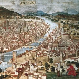
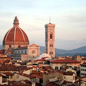
16th Century Plan of Florence
16th century plan of Florence, Italy. Detail from the map of Etruria (Tuscany and Northern Lazio), in the Gallery of Maps in the Vatican Museum.The Gallery of Maps holds maps which were commissioned between 1578 and 1580 to show the regions of Italy and territories of the church. The maps are based on the work of Ignazio Danti, a 16th century Italian priest, mathematician, astronomer and cosmographer, and are an important record of 16th century geography. Vatican Museum
Science Photo Library features Science and Medical images including photos and illustrations
Media ID 6321643
© Sheila Terry
1500s 16th Century Atlas Cartography Earth Science Florence Gallery Of Maps Ignazio Danti Italian Italy Mapping Maps Plan Sciences Sixteenth Century Etruria
21"x14" (+3" Border) Fine Art Print
Discover the rich history of Florence, Italy with our exquisite Fine Art Print from the Media Storehouse collection. This stunning 16th century plan of Florence, captured by Science Photo Library, offers a captivating glimpse into the past. Originally part of the Map of Etruria (Tuscany and Northern Lazio) in the Gallery of Maps in the Vatican Museum, this detailed map showcases the architectural wonders and urban layout of Florence during the Renaissance period. Bring the beauty and history of this iconic city into your home or office with our museum-quality Fine Art Prints, expertly printed on premium paper for lasting brilliance and vibrancy.
21x14 image printed on 27x20 Fine Art Rag Paper with 3" (76mm) white border. Our Fine Art Prints are printed on 300gsm 100% acid free, PH neutral paper with archival properties. This printing method is used by museums and art collections to exhibit photographs and art reproductions.
Our fine art prints are high-quality prints made using a paper called Photo Rag. This 100% cotton rag fibre paper is known for its exceptional image sharpness, rich colors, and high level of detail, making it a popular choice for professional photographers and artists. Photo rag paper is our clear recommendation for a fine art paper print. If you can afford to spend more on a higher quality paper, then Photo Rag is our clear recommendation for a fine art paper print.
Estimated Image Size (if not cropped) is 53.3cm x 35.5cm (21" x 14")
Estimated Product Size is 68.6cm x 50.8cm (27" x 20")
These are individually made so all sizes are approximate
Artwork printed orientated as per the preview above, with landscape (horizontal) orientation to match the source image.
FEATURES IN THESE COLLECTIONS
> Europe
> Italy
> Lazio
> Related Images
> Europe
> Italy
> Tuscany
> Florence
> Europe
> Italy
> Tuscany
> Related Images
> Maps and Charts
> Early Maps
> Maps and Charts
> Italy
> Maps and Charts
> Related Images
EDITORS COMMENTS
This print showcases a remarkable 16th-century plan of Florence, Italy. Extracted from the larger map of Etruria (Tuscany and Northern Lazio) housed in the prestigious Gallery of Maps at the Vatican Museum, this detail offers a glimpse into the rich history and geography of Renaissance-era Florence. Commissioned between 1578 and 1580, these maps were created to depict various regions of Italy as well as territories belonging to the Church. The mastermind behind these intricate cartographic works was Ignazio Danti, an esteemed Italian priest, mathematician, astronomer, and cosmographer. His expertise in multiple fields allowed him to craft accurate representations that serve as invaluable records of 16th-century geography. The significance of this particular print lies not only in its historical importance but also in its artistic beauty. The illustration transports viewers back to a time when Florentine culture flourished under Medici patronage and iconic landmarks like Brunelleschi's Dome dominated the cityscape. As we delve into this snapshot from Earth's past, we are reminded of how science intertwines with artistry through cartography. This mesmerizing image invites us to appreciate both the scientific advancements made during the Renaissance period and their visual representation on paper—a testament to human curiosity and ingenuity that continues to inspire us today.
MADE IN AUSTRALIA
Safe Shipping with 30 Day Money Back Guarantee
FREE PERSONALISATION*
We are proud to offer a range of customisation features including Personalised Captions, Color Filters and Picture Zoom Tools
SECURE PAYMENTS
We happily accept a wide range of payment options so you can pay for the things you need in the way that is most convenient for you
* Options may vary by product and licensing agreement. Zoomed Pictures can be adjusted in the Cart.