Home > North America > Cuba > Cuba Heritage Sites > Trinidad and the Valley de los Ingenios
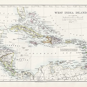
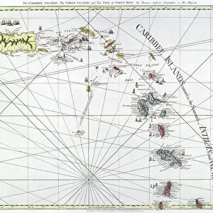
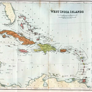
Vintage map of the West India Islands 1860s

![]()
Wall Art and Photo Gifts from Fine Art Storehouse
Vintage map of the West India Islands 1860s
Unleash your creativity and transform your space into a visual masterpiece!
duncan1890
Media ID 13666613
© duncan1890
1860 1869 Antilles Bahamas Barbados Caribbean Caribbean Culture Cayman Islands Cuba Dominican Republic Ephemera Geographical Locations Greater Antilles Haiti Hispaniola Illustrations And Vector Art Image Created 1860 1869 Image Date Jamaica Lesser Antilles Navigational Equipment Pacific Islands Puerto Rico The Americas Travel Locations Trinidad And Tobago Turks And Caicos Islands West Indies Windward Islands Caribbean French Antilles Image Created 19th Century Leeward Islands Windward Islands
FEATURES IN THESE COLLECTIONS
> Fine Art Storehouse
> Map
> Historical Maps
> Maps and Charts
> Early Maps
> Maps and Charts
> India
> North America
> The Bahamas
> Maps
> North America
> Barbados
> Maps
> North America
> Cuba
> Cuba Heritage Sites
> Trinidad and the Valley de los Ingenios
> North America
> Cuba
> Maps
> North America
> Dominican Republic
> Maps
> North America
> Haiti
> Maps
EDITORS COMMENTS
This vintage map of the West India Islands from the 1860s takes us on a journey back in time. With its intricate details and exquisite engraving, it showcases the beauty and cultural richness of the Caribbean region during that era. The map encompasses a vast area, stretching from the Leeward Islands to Labadee, capturing islands such as Turks and Caicos, Trinidad and Tobago, Haiti, Puerto Rico, Cuba, Jamaica, and many more. It offers a glimpse into the historical significance of these places within the context of trade routes and colonial influence. Painted with an illustration technique characteristic of the 19th century, this image serves as both a piece of artistry and an important historical document. Its depiction of navigational equipment adds another layer to its charm by reminding us of past exploration endeavors. As we explore this antique map further, we are transported to a time when cartography was not only about practicality but also about aesthetics. The attention to detail is evident in every stroke: from geographical locations meticulously marked to delicate illustrations scattered across landmasses. This print captures not just history but also evokes curiosity about how life might have been in these vibrant Caribbean islands over 150 years ago. It is truly a treasure for any lover of art or history seeking to delve into the enchanting world that once existed in this corner of "the Americas. "
MADE IN AUSTRALIA
Safe Shipping with 30 Day Money Back Guarantee
FREE PERSONALISATION*
We are proud to offer a range of customisation features including Personalised Captions, Color Filters and Picture Zoom Tools
SECURE PAYMENTS
We happily accept a wide range of payment options so you can pay for the things you need in the way that is most convenient for you
* Options may vary by product and licensing agreement. Zoomed Pictures can be adjusted in the Cart.