Jigsaw Puzzle > Maps and Charts > Related Images
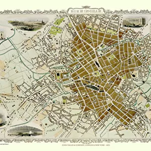
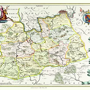
Jigsaw Puzzle : Old Map of Birmingham 1795 by C. Pye


![]()
Jigsaw Puzzles from MapSeeker
Old Map of Birmingham 1795 by C. Pye
J073
Welcome to the Mapseeker Image library and enter an historic gateway to one of the largest on-line collections of Historic Maps, Nostalgic Views, Vista's and Panorama's from a World gone by.
Media ID 20347114
Birmingham Birmingham City Birmingham City Map Birmingham Map Birmingham Town Plan Historic Birmingham Map Historic Map Map Of Birmingham Old Map Of Birmingham Old Town Plan Town Plan Of Birmingham
Jigsaw Puzzle (1000 Pieces)
Discover the rich history of Birmingham with our captivating Old Map of Birmingham 1795 Jigsaw Puzzle from Media Storehouse. This intricately detailed puzzle, featuring an antique map by C. Pye from MapSeeker (J073), invites you on a journey back in time. Immerse yourself in the intricacies of this 500-piece puzzle, perfect for puzzle enthusiasts and history buffs alike. Assemble the puzzle pieces to reveal the fascinating layout of Birmingham as it appeared over 200 years ago. A delightful activity for individuals or a fun challenge for the whole family, this Old Map of Birmingham 1795 Jigsaw Puzzle is a must-have for anyone seeking an engaging and educational pastime.
1000 piece puzzles are custom made in Australia and hand-finished on 100% recycled 1.6mm thick laminated puzzle boards. There is a level of repetition in jigsaw shapes with each matching piece away from its pair. The completed puzzle measures 76x50cm and is delivered packaged in an attractive presentation box specially designed to fit most mail slots with a unique magnetic lid
Jigsaw Puzzles are an ideal gift for any occasion
Estimated Product Size is 76cm x 50.2cm (29.9" x 19.8")
These are individually made so all sizes are approximate
Artwork printed orientated as per the preview above, with landscape (horizontal) or portrait (vertical) orientation to match the source image.
FEATURES IN THESE COLLECTIONS
> Maps and Charts
> Related Images
> MapSeeker
> British Town And City Plans
> English & Welsh PORTFOLIO
EDITORS COMMENTS
This print showcases the "Old Map of Birmingham 1795" by C. Pye (J073), offering a mesmerizing glimpse into the rich history of this vibrant city. Dating back to over two centuries ago, this meticulously detailed map provides an invaluable window into the past, allowing us to explore and appreciate how Birmingham has evolved throughout time. As we delve into this historic treasure, we are transported to a bygone era where quaint streets and bustling markets painted the landscape. The intricate town plan of Birmingham reveals its early layout, highlighting significant landmarks that have shaped its identity. From St. Philip's Cathedral standing tall in the heart of the city to charming squares and winding alleys that once bustled with activity, every corner tells a story waiting to be discovered. The skilled craftsmanship evident in this old map is truly remarkable; it serves as a testament to C. Pye's dedication in capturing even the smallest details with precision and artistry. This print allows us not only to admire his work but also offers an opportunity for historians, enthusiasts, or anyone curious about Birmingham's roots to immerse themselves in its past glory. Whether you call Birmingham home or simply hold an appreciation for historical cartography, this image will undoubtedly spark your imagination and transport you on a journey through time – reminding us all of our connection with those who walked these streets long before us.
MADE IN AUSTRALIA
Safe Shipping with 30 Day Money Back Guarantee
FREE PERSONALISATION*
We are proud to offer a range of customisation features including Personalised Captions, Color Filters and Picture Zoom Tools
SECURE PAYMENTS
We happily accept a wide range of payment options so you can pay for the things you need in the way that is most convenient for you
* Options may vary by product and licensing agreement. Zoomed Pictures can be adjusted in the Cart.