Metal Print > Maps and Charts > Related Images
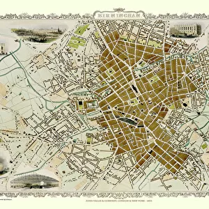
Metal Print : Old Map of Birmingham 1795 by C. Pye


![]()
Metal Prints from MapSeeker
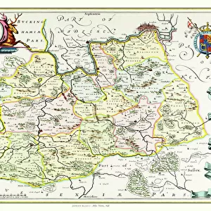
Old Map of Birmingham 1795 by C. Pye
J073
Welcome to the Mapseeker Image library and enter an historic gateway to one of the largest on-line collections of Historic Maps, Nostalgic Views, Vista's and Panorama's from a World gone by.
Media ID 20347114
Birmingham Birmingham City Birmingham City Map Birmingham Map Birmingham Town Plan Historic Birmingham Map Historic Map Map Of Birmingham Old Map Of Birmingham Old Town Plan Town Plan Of Birmingham
14"x11" (28x35cm) Metal Print
Step back in time with our Old Map of Birmingham 1795 Metal Print from Media Storehouse and MapSeeker (J073). This beautiful metal print features an intricately detailed antique map of Birmingham, as originally created by C. Pye over 200 years ago. The vintage charm of this map is brought to life through our high-quality metal printing process, which produces vibrant colors and stunning clarity. The sleek, modern metal surface adds a unique and contemporary twist to this historical piece, making it a perfect addition to any home or office. Order your Old Map of Birmingham 1795 Metal Print today and bring a piece of history into your space.
Our Metal Prints feature rounded corners and rear fixings for easy wall mounting. Images are directly printed onto a lightweight, high quality 5mm thick, durable metallic surface for a vivid and vibrant finish. Available in 2 sizes, 28x35cm (14x11) and 50x40cm (20x16). The unique material is fade, moisture, chemical and scratch resistant to help ensure this art lasts a lifetime.
Made with durable metal and luxurious printing techniques, metal prints bring images to life and add a modern touch to any space
Estimated Product Size is 35.5cm x 27.9cm (14" x 11")
These are individually made so all sizes are approximate
Artwork printed orientated as per the preview above, with landscape (horizontal) or portrait (vertical) orientation to match the source image.
FEATURES IN THESE COLLECTIONS
> MapSeeker
> British Town And City Plans
> English & Welsh PORTFOLIO
> Maps and Charts
> Related Images
EDITORS COMMENTS
This print showcases the "Old Map of Birmingham 1795" by C. Pye (J073), offering a mesmerizing glimpse into the rich history of this vibrant city. Dating back to over two centuries ago, this meticulously detailed map provides an invaluable window into the past, allowing us to explore and appreciate how Birmingham has evolved throughout time. As we delve into this historic treasure, we are transported to a bygone era where quaint streets and bustling markets painted the landscape. The intricate town plan of Birmingham reveals its early layout, highlighting significant landmarks that have shaped its identity. From St. Philip's Cathedral standing tall in the heart of the city to charming squares and winding alleys that once bustled with activity, every corner tells a story waiting to be discovered. The skilled craftsmanship evident in this old map is truly remarkable; it serves as a testament to C. Pye's dedication in capturing even the smallest details with precision and artistry. This print allows us not only to admire his work but also offers an opportunity for historians, enthusiasts, or anyone curious about Birmingham's roots to immerse themselves in its past glory. Whether you call Birmingham home or simply hold an appreciation for historical cartography, this image will undoubtedly spark your imagination and transport you on a journey through time – reminding us all of our connection with those who walked these streets long before us.
MADE IN AUSTRALIA
Safe Shipping with 30 Day Money Back Guarantee
FREE PERSONALISATION*
We are proud to offer a range of customisation features including Personalised Captions, Color Filters and Picture Zoom Tools
SECURE PAYMENTS
We happily accept a wide range of payment options so you can pay for the things you need in the way that is most convenient for you
* Options may vary by product and licensing agreement. Zoomed Pictures can be adjusted in the Cart.