Jigsaw Puzzle > Animals > Mammals > Cats (Wild) > Populator
Jigsaw Puzzle : North America at night, satellite image


![]()
Jigsaw Puzzles from Science Photo Library
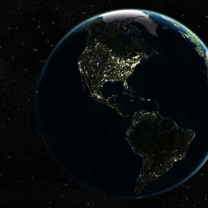
North America at night, satellite image
North America at night, satellite image. City lights (yellow) show areas of dense population, particularly in North America (upper centre). Most of South America (bottom right) is uninhabited, as is the Arctic (top). This image was produced by combining data from the Defense Meteorological Satellite Program (DMSP) and NOas POES satellites
Science Photo Library features Science and Medical images including photos and illustrations
Media ID 1705077
© PLANETARY VISIONS LTD/SCIENCE PHOTO LIBRARY
Arctic Artificial Lighting Caribbean Central America Cities City Combined Data Continent Continents Dark Darkness Defense Meteorological Demographics Demography Densely Populated Density Distribution Dmsp Earth Observation Earth Science Energy Environmental Impact From Space Globe Human Geography Human Population Inhabited Light Light Pollution Lights Night Night Time Noaa North Pole Pacific Ocean Poes Polar Orbiter Populated Population Power Region Satellite Satellite Image Satellite Program South America Sparsely Populated Uninhabited Urban Urban Geography Urbanisation Urbanised Urbanization Urbanized Us A World The Americas
Jigsaw Puzzle (500 Pieces)
Discover the mesmerizing beauty of North America after dark with our Media Storehouse Jigsaw Puzzles. This captivating puzzle, featuring a satellite image from Science Photo Library, invites you on a journey to explore the vibrant city lights (yellow) that illuminate the dense population areas, particularly in North America. Assemble this intricately detailed puzzle piece by piece and let the enchanting nighttime landscape unfold before your eyes. A perfect activity for puzzle enthusiasts and geography lovers alike, this North America at night puzzle is sure to provide hours of relaxation and enjoyment.
500 piece puzzles are custom made in Australia and hand-finished on 100% recycled 1.6mm thick laminated puzzle boards. There is a level of repetition in jigsaw shapes with each matching piece away from its pair. The completed puzzle measures 40x51cm and is delivered packaged in an attractive presentation box specially designed to fit most mail slots with a unique magnetic lid
Jigsaw Puzzles are an ideal gift for any occasion
Estimated Product Size is 40.3cm x 50.7cm (15.9" x 20")
These are individually made so all sizes are approximate
Artwork printed orientated as per the preview above, with landscape (horizontal) or portrait (vertical) orientation to match the source image.
FEATURES IN THESE COLLECTIONS
> Animals
> Mammals
> Cats (Wild)
> Populator
> Arts
> Artists
> O
> Oceanic Oceanic
> North America
> Related Images
> Science
> Space Exploration
> Planets
> Earth
> South America
> Related Images
> Science Photo Library
> Aerial and Satellite
EDITORS COMMENTS
Great image of North America at night, as captured by combining data from the Defense Meteorological Satellite Program (DMSP) and NOAA's POES satellites. In this satellite image, city lights (yellow) illuminate areas of dense population, particularly in North America, located in the upper center of the image. The distribution of urbanized areas is evident, with the United States and Canada showing significant concentrations of light. Most of South America, located at the bottom right of the image, remains uninhabited, as does the Arctic region at the top. The Caribbean Sea and the Gulf of Mexico also exhibit pockets of light, indicating human presence. This image provides a unique perspective on the Earth's geography, highlighting the distribution of population and urbanization in the Americas during the 21st century. The contrast between the lit areas and the surrounding darkness offers a striking reminder of the technological advancements and energy consumption of urban centers. The image was produced by combining data from DMSP and NOAA's Polar-orbiting Operational Environmental Satellite (POES), which have been used for earth observation and environmental impact assessments, including monitoring urban growth and light pollution. The urbanization of North America, as depicted in this image, is a testament to the demographic shifts and human geography of the region. The image also raises important questions about the environmental impact of urbanization and the role of technology in shaping our planet. Overall, this satellite image offers a fascinating glimpse into the Earth's urban landscapes and the distribution of human population in the 21st century. The combination of data from DMSP and NOAA's POES satellites provides valuable insights into the geography, demographics, and environmental impact of urbanization in the Americas.
MADE IN AUSTRALIA
Safe Shipping with 30 Day Money Back Guarantee
FREE PERSONALISATION*
We are proud to offer a range of customisation features including Personalised Captions, Color Filters and Picture Zoom Tools
SECURE PAYMENTS
We happily accept a wide range of payment options so you can pay for the things you need in the way that is most convenient for you
* Options may vary by product and licensing agreement. Zoomed Pictures can be adjusted in the Cart.