Home > Africa > The Gambia > Maps
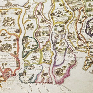
1865, Bellin Sea Chart of Western Africa, Senegal, Gambia, Guinea, etc. topography

![]()
Wall Art and Photo Gifts from Liszt Collection
1865, Bellin Sea Chart of Western Africa, Senegal, Gambia, Guinea, etc. topography
1865, Bellin Sea Chart of Western Africa, Senegal, Gambia, Guinea, etc
Liszt Collection of nineteenth-century engravings and images to browse and enjoy
Media ID 14006080
© Artokoloro Quint Lox Limited
Gambia Guinea Senegal Antique Map Atlas Chart Geographic Latitude Longitude Mappa Mundi Old Antique Plan Old Antique View Old Map Ols Antique Map Rare Old Maps Topo
FEATURES IN THESE COLLECTIONS
> Africa
> The Gambia
> Maps
> Maps and Charts
> Early Maps
> Maps and Charts
> World
EDITORS COMMENTS
This print showcases a remarkable piece of history - the 1865 Bellin Sea Chart of Western Africa. With its intricate details and stunning topography, this chart offers a glimpse into the past, specifically focusing on Senegal, Gambia, Guinea, and other regions in Western Africa. The artistry behind this vintage map is evident as it beautifully illustrates the geographic features of the land. The carefully plotted grid lines denote latitude and longitude coordinates, allowing for precise navigation across these African territories. Its antique charm adds to its allure, making it an ideal decorative piece for any history enthusiast or travel lover. As we gaze upon this aged treasure from centuries ago, we are transported back in time to an era of exploration and discovery. This rare old map not only serves as a testament to human curiosity but also provides valuable insights into how our understanding of geography has evolved over time. Whether displayed in a study or showcased in a gallery space dedicated to historical artifacts, this Bellin Sea Chart is sure to captivate viewers with its rich heritage and artistic craftsmanship. It reminds us that even though technology has transformed navigation today, there is still immense value in appreciating the beauty and significance of ancient cartography like this one from Liszt Collection's archives.
MADE IN AUSTRALIA
Safe Shipping with 30 Day Money Back Guarantee
FREE PERSONALISATION*
We are proud to offer a range of customisation features including Personalised Captions, Color Filters and Picture Zoom Tools
SECURE PAYMENTS
We happily accept a wide range of payment options so you can pay for the things you need in the way that is most convenient for you
* Options may vary by product and licensing agreement. Zoomed Pictures can be adjusted in the Cart.