Home > Maps and Charts > World
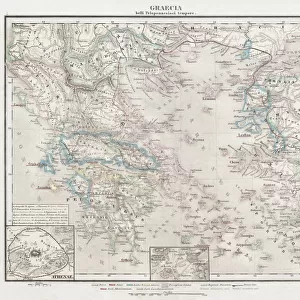
1865, Spruner Map of the Mediterranean from the Punic Wars to Mithridates the Great

![]()
Wall Art and Photo Gifts from Liszt Collection
1865, Spruner Map of the Mediterranean from the Punic Wars to Mithridates the Great
Liszt Collection of nineteenth-century engravings and images to browse and enjoy
Media ID 14007936
© Artokoloro Quint Lox Limited
Antique Map Atlas Chart Geographic Latitude Longitude Mappa Mundi Old Antique Plan Old Antique View Old Map Ols Antique Map Rare Old Maps Topo
FEATURES IN THESE COLLECTIONS
> Maps and Charts
> Early Maps
> Maps and Charts
> World
EDITORS COMMENTS
This print showcases the remarkable "1865, Spruner Map of the Mediterranean from the Punic Wars to Mithridates the Great". A true masterpiece of cartography and historical illustration, this vintage map takes us on a journey through time and space. With its intricate topography and precise geographic details, this map offers a window into ancient history. It beautifully captures the vast expanse of land surrounding the Mediterranean Sea, depicting regions that witnessed significant events such as the Punic Wars and Mithridates' reign. The aged paper adds an authentic touch to this decorative piece, evoking a sense of nostalgia for bygone eras. Its artistic design combines elements of navigation charts with latitude and longitude grids, creating a visually stunning composition. As we gaze upon this rare old map, our imagination is ignited with thoughts of exploration and discovery. We can almost envision ancient civilizations thriving along these shores while adventurers set sail in search of new lands. The Liszt Collection has preserved this antique treasure for us to admire today. With its rich historical significance and meticulous attention to detail, it serves as a testament to human curiosity about our world's past. Whether you are an avid collector or simply appreciate artful representations of history, this print is sure to captivate your senses and transport you back in time.
MADE IN AUSTRALIA
Safe Shipping with 30 Day Money Back Guarantee
FREE PERSONALISATION*
We are proud to offer a range of customisation features including Personalised Captions, Color Filters and Picture Zoom Tools
SECURE PAYMENTS
We happily accept a wide range of payment options so you can pay for the things you need in the way that is most convenient for you
* Options may vary by product and licensing agreement. Zoomed Pictures can be adjusted in the Cart.