Home > Arts > Artists > H > Jodocus Hondius
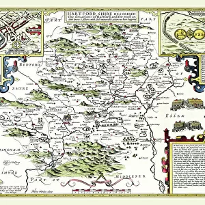
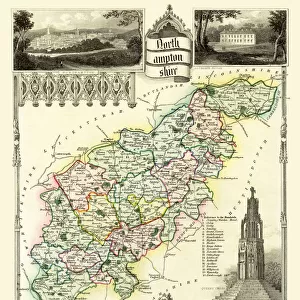
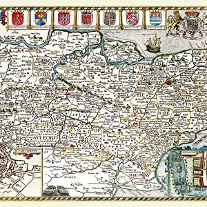
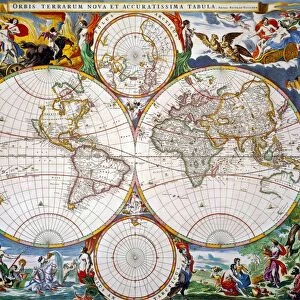
Old County Map of Hertfordshire 1648 by Johan Blaeu from the Atlas Novus

![]()
Wall Art and Photo Gifts from MapSeeker
Old County Map of Hertfordshire 1648 by Johan Blaeu from the Atlas Novus
This detailed and most attractive reproduction map of Hertfordshire has been carefully art worked from a scan of an antique original. The famous firm of Dutch cartographers and publishers was established in the late 16th century by Willem Janszoon Blaeu in Amsterdam. Blaeu was a maker of globes and scientific instruments and purchased some of his early map plates from Jodocus Hondius. From this small beginning was to emerge one of the largest and most prolific map publishing houses of the seventeenth century
Welcome to the Mapseeker Image library and enter an historic gateway to one of the largest on-line collections of Historic Maps, Nostalgic Views, Vista's and Panorama's from a World gone by.
Media ID 20347828
Blaeu Blaeu Family County Map County Map Of England English County Map Historic Map Johan Blaeu Johan Blaeu Map Old Blaue Map Old County Map Old English County Map Hertfordshire
FEATURES IN THESE COLLECTIONS
> MapSeeker
> Maps from the British Isles
> England and Counties PORTFOLIO
> Arts
> Artists
> B
> Willem Blaeu
> Arts
> Artists
> H
> Jodocus Hondius
> Arts
> Photorealistic artworks
> Detailed art pieces
> Masterful detailing in art
> Europe
> United Kingdom
> England
> Hampshire
> Related Images
> Europe
> United Kingdom
> England
> Hertfordshire
> Related Images
> Europe
> United Kingdom
> England
> Maps
> Maps and Charts
> Early Maps
> Maps and Charts
> Willem Janszoon Blaeu
EDITORS COMMENTS
This beautifully crafted reproduction of the "Old County Map of Hertfordshire 1648" by Johan Blaeu takes us back in time to explore the rich history and intricate details of this English county. Carefully art worked from a scan of an antique original, this map captures the essence of Hertfordshire during the 17th century. Johan Blaeu, a renowned Dutch cartographer and publisher, established his firm in Amsterdam during the late 16th century. Originally known for his globes and scientific instruments, Blaeu's passion for mapping led him to acquire map plates from Jodocus Hondius. From these humble beginnings, the Blaeu family would go on to become one of the largest and most prolific map publishing houses of their time. The "Old County Map of Hertfordshire" showcases not only its historical significance but also its aesthetic appeal. Every line and curve meticulously drawn on this map tells a story about Hertfordshire's past - its towns, villages, rivers, roads, and landmarks that have shaped its identity over centuries. As we gaze upon this historic treasure, we are transported back to a time when maps were hand-drawn with precision and care. It serves as a reminder that even in our modern world filled with digital technology, there is still something captivating about holding onto tangible pieces of history like this remarkable piece by Johan Blaeu.
MADE IN AUSTRALIA
Safe Shipping with 30 Day Money Back Guarantee
FREE PERSONALISATION*
We are proud to offer a range of customisation features including Personalised Captions, Color Filters and Picture Zoom Tools
SECURE PAYMENTS
We happily accept a wide range of payment options so you can pay for the things you need in the way that is most convenient for you
* Options may vary by product and licensing agreement. Zoomed Pictures can be adjusted in the Cart.