Metal Print : 1770, Bonne Map of East Africa, Madagascar, Isle Bourbon and Mauritius, Mozambique


![]()
Metal Prints from Liszt Collection
1770, Bonne Map of East Africa, Madagascar, Isle Bourbon and Mauritius, Mozambique
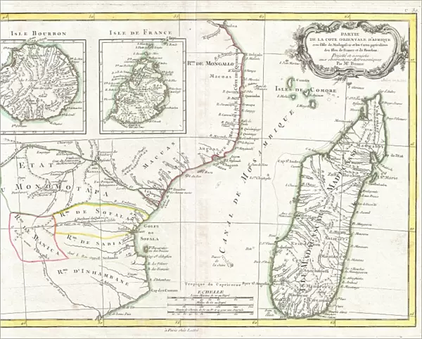
1770, Bonne Map of East Africa, Madagascar, Isle Bourbon and Mauritius, Mozambique, Rigobert Bonne 1727 - 1794, one of the most important cartographers of the late 18th century
Liszt Collection of nineteenth-century engravings and images to browse and enjoy
Media ID 14004662
© Artokoloro Quint Lox Limited
1770 Madagascar Rigobert Bonne 1727 1794 Rigobert Bonne 1727 – 1794 Rigobert Bonne 17271794 Antique Map Atlas Chart Geographic Latitude Longitude Mappa Mundi Mozambique Old Antique Plan Old Antique View Old Map Ols Antique Map Rare Old Maps Topo
10"x8" (25x20cm) Table Top Metal Print
Discover the rich history of East Africa with our stunning Media Storehouse Metal Print of the 1770 Bonne Map. This exquisite piece, from the renowned cartographer Rigobert Bonne's collection, showcases intricate detail of Madagascar, Isle Bourbon, Mauritius, and Mozambique. Each metal print is meticulously crafted, preserving the vintage charm of the original map while adding a contemporary twist with a sleek, durable metal finish. Bring a piece of cartographic history into your home or office and transport yourself back in time with this captivating work of art.
Table Top Metal Prints feature rounded corners and an easel back for easy display. Available in two sizes, 18x13cm (7x5) or 25x20cm (10x8). Lightweight and vibrant, they are perfect for displaying artwork and are guaranteed to add style to any desk or table top. The unique material is fade, moisture, chemical and scratch resistant to help ensure this art lasts a lifetime.
Made with durable metal and luxurious printing techniques, metal prints bring images to life and add a modern touch to any space
Estimated Product Size is 25.4cm x 20.3cm (10" x 8")
These are individually made so all sizes are approximate
Artwork printed orientated as per the preview above, with landscape (horizontal) or portrait (vertical) orientation to match the source image.
EDITORS COMMENTS
This print showcases the remarkable "1770, Bonne Map of East Africa, Madagascar, Isle Bourbon and Mauritius, Mozambique" created by Rigobert Bonne. As one of the most influential cartographers of the late 18th century, Bonne's expertise in topography and geography is beautifully illustrated in this vintage piece. The map takes us on a journey through time as we explore the intricate details of East Africa and its surrounding regions. With meticulous precision, Bonne captures the geographic features with an artistic touch that transports us to a bygone era. The carefully drawn lines depict latitude and longitude grids while showcasing the region's diverse landscapes. As we delve into this ancient world presented on paper, we are reminded of the historical significance embedded within each stroke. This decorative piece not only serves as a navigational tool but also acts as a window into past discoveries and explorations. With its aged appearance adding to its allure, this rare antique map invites us to appreciate both its aesthetic beauty and educational value. It stands as a testament to Bonne's mastery in cartography while offering glimpses into forgotten lands waiting to be rediscovered. Whether displayed for personal enjoyment or used for educational purposes, this extraordinary print from Liszt Collection allows us to marvel at our planet's rich history while igniting our curiosity about distant places and times long gone.
MADE IN AUSTRALIA
Safe Shipping with 30 Day Money Back Guarantee
FREE PERSONALISATION*
We are proud to offer a range of customisation features including Personalised Captions, Color Filters and Picture Zoom Tools
SECURE PAYMENTS
We happily accept a wide range of payment options so you can pay for the things you need in the way that is most convenient for you
* Options may vary by product and licensing agreement. Zoomed Pictures can be adjusted in the Cart.