Metal Print > Europe > United Kingdom > Scotland > Scottish Borders > Peebles
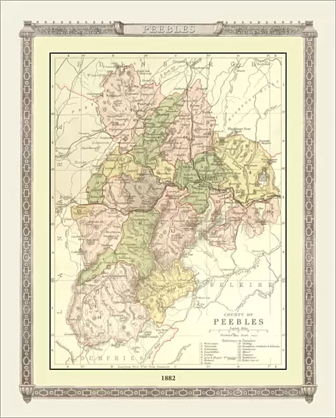
Metal Print : Old Map of the County of Peebles from the Philips Handy Atlas of 1882


![]()
Metal Prints from MapSeeker
Old Map of the County of Peebles from the Philips Handy Atlas of 1882
PHA023
Welcome to the Mapseeker Image library and enter an historic gateway to one of the largest on-line collections of Historic Maps, Nostalgic Views, Vista's and Panorama's from a World gone by.
Media ID 20348215
County Map County Map Of Scotland Historic Map Old County Map Old Scottish County Map Scottish County Map Peebles
10"x8" (25x20cm) Table Top Metal Print
Step back in time with our exquisite Metal Print of an Old Map of Peebles County from the Philips Handy Atlas of 1882, sourced from MapSeeker. This vintage map print, featuring the County of Peebles, is meticulously transferred onto a high-quality metal sheet, giving it a unique and distinctive look. The metallic finish adds depth and dimension to the intricate details of the map, making it a stunning addition to any room. Relive history and add a touch of timeless charm to your decor with this beautiful piece from the Media Storehouse range of Metal Prints.
Table Top Metal Prints feature rounded corners and an easel back for easy display. Available in two sizes, 18x13cm (7x5) or 25x20cm (10x8). Lightweight and vibrant, they are perfect for displaying artwork and are guaranteed to add style to any desk or table top. The unique material is fade, moisture, chemical and scratch resistant to help ensure this art lasts a lifetime.
Made with durable metal and luxurious printing techniques, metal prints bring images to life and add a modern touch to any space
Estimated Product Size is 20.3cm x 25.4cm (8" x 10")
These are individually made so all sizes are approximate
Artwork printed orientated as per the preview above, with landscape (horizontal) or portrait (vertical) orientation to match the source image.
FEATURES IN THESE COLLECTIONS
> MapSeeker
> Maps from the British Isles
> Scotland and Counties PORTFOLIO
> Europe
> United Kingdom
> Scotland
> Maps
> Europe
> United Kingdom
> Scotland
> Scottish Borders
> Peebles
> Maps and Charts
> Early Maps
> Maps and Charts
> Related Images
EDITORS COMMENTS
This print showcases an exquisite piece of history, the "Old Map of the County of Peebles from the Philips Handy Atlas of 1882". Delve into a bygone era as you explore this Scottish county map, meticulously crafted over a century ago. The intricate details and elegant design transport you to a time when cartography was an art form. Immerse yourself in the rich heritage of Peebles County through this historic map. Every contour and boundary tells a story, revealing how landscapes have evolved and settlements have grown throughout time. Trace your finger along winding rivers, ancient roads, and quaint villages that once thrived within these borders. As you gaze upon this remarkable artifact, let your imagination wander back to 19th-century Scotland. Picture horse-drawn carriages traversing rugged terrains while locals go about their daily lives amidst breathtaking natural beauty. This old county map serves as a window into an era long gone but not forgotten. Whether you are a history enthusiast or simply appreciate fine craftsmanship, this print is sure to captivate your senses. Display it proudly in your home or office as both a conversation starter and homage to the past. Let its historical charm transport you on an enchanting journey through Peebles County's fascinating legacy.
MADE IN AUSTRALIA
Safe Shipping with 30 Day Money Back Guarantee
FREE PERSONALISATION*
We are proud to offer a range of customisation features including Personalised Captions, Color Filters and Picture Zoom Tools
SECURE PAYMENTS
We happily accept a wide range of payment options so you can pay for the things you need in the way that is most convenient for you
* Options may vary by product and licensing agreement. Zoomed Pictures can be adjusted in the Cart.