Photo Mug > Europe > United Kingdom > Scotland > Scottish Borders > Peebles
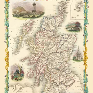
Photo Mug : Old Map of the County of Peebles from the Philips Handy Atlas of 1882


![]()
Home Decor from MapSeeker
Old Map of the County of Peebles from the Philips Handy Atlas of 1882
PHA023
Welcome to the Mapseeker Image library and enter an historic gateway to one of the largest on-line collections of Historic Maps, Nostalgic Views, Vista's and Panorama's from a World gone by.
Media ID 20348215
County Map County Map Of Scotland Historic Map Old County Map Old Scottish County Map Scottish County Map Peebles
Photo Mug
Add a touch of history to your morning routine with our Media Storehouse Photo Mug featuring an Old Map of Peebles County from the Philips Handy Atlas of 1882, sourced from MapSeeker. Each mug showcases high-quality, vibrant prints that bring the intricate details of this antique map to life. Perfect for tea or coffee, these sturdy mugs are microwave and dishwasher safe, making them a practical and unique gift for history enthusiasts and map collectors alike. Travel back in time with every sip.
A personalised photo mug blends sentimentality with functionality, making an ideal gift for cherished loved ones, close friends, or valued colleagues. Preview may show both sides of the same mug.
Elevate your coffee or tea experience with our premium white ceramic mug. Its wide, comfortable handle makes drinking easy, and you can rely on it to be both microwave and dishwasher safe. Sold in single units, preview may show both sides of the same mug so you can see how the picture wraps around.
Mug Size is 9.6cm high x 8.1cm diameter (3.8" x 3.2")
These are individually made so all sizes are approximate
FEATURES IN THESE COLLECTIONS
> MapSeeker
> Maps from the British Isles
> Scotland and Counties PORTFOLIO
> Europe
> United Kingdom
> Scotland
> Maps
> Europe
> United Kingdom
> Scotland
> Posters
> Europe
> United Kingdom
> Scotland
> Related Images
> Europe
> United Kingdom
> Scotland
> Scottish Borders
> Peebles
> Maps and Charts
> Early Maps
> Maps and Charts
> Related Images
EDITORS COMMENTS
This print showcases an exquisite piece of history, the "Old Map of the County of Peebles from the Philips Handy Atlas of 1882". Delve into a bygone era as you explore this Scottish county map, meticulously crafted over a century ago. The intricate details and elegant design transport you to a time when cartography was an art form. Immerse yourself in the rich heritage of Peebles County through this historic map. Every contour and boundary tells a story, revealing how landscapes have evolved and settlements have grown throughout time. Trace your finger along winding rivers, ancient roads, and quaint villages that once thrived within these borders. As you gaze upon this remarkable artifact, let your imagination wander back to 19th-century Scotland. Picture horse-drawn carriages traversing rugged terrains while locals go about their daily lives amidst breathtaking natural beauty. This old county map serves as a window into an era long gone but not forgotten. Whether you are a history enthusiast or simply appreciate fine craftsmanship, this print is sure to captivate your senses. Display it proudly in your home or office as both a conversation starter and homage to the past. Let its historical charm transport you on an enchanting journey through Peebles County's fascinating legacy.
MADE IN AUSTRALIA
Safe Shipping with 30 Day Money Back Guarantee
FREE PERSONALISATION*
We are proud to offer a range of customisation features including Personalised Captions, Color Filters and Picture Zoom Tools
SECURE PAYMENTS
We happily accept a wide range of payment options so you can pay for the things you need in the way that is most convenient for you
* Options may vary by product and licensing agreement. Zoomed Pictures can be adjusted in the Cart.