Metal Print > Maps and Charts > Gerardus Mercator's Cartographic
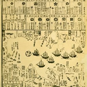
Metal Print : 17th century map of Japan


![]()
Metal Prints from Science Photo Library
17th century map of Japan
Japan, 17th century Dutch map. These lands had not yet been accurately mapped by Europeans, and the islands of Japan (centre to centre right) are much distorted. Korea (upper left) is still shown as an island, though the text notes that this may not be correct. Illustrations include a European sailing ship (top centre), a Chinese junk (lower centre) and a sea monster (lower left). This map was by Joducus Hondius, based on earlier maps. It was first published in 1606 as a new addition to his atlas that reissued the work of Gerard Mercator
Science Photo Library features Science and Medical images including photos and illustrations
Media ID 6349099
© GEORGETTE DOUWMA/SCIENCE PHOTO LIBRARY
17th Century Age Of Discovery Ancient Cartography Distorted Distortion Dutch Earth Science Exploration Exploring Far East Illustrated Inaccurate Incomplete Japan Japanese Korea Korean Latin Mapping Maps Mercator Sciences Seventeenth 1606 Gerard Gerardus Hondius Jodocus
10"x8" (25x20cm) Table Top Metal Print
Discover the captivating allure of the past with our Media Storehouse Metal Prints featuring a rare 17th century map of Japan from Science Photo Library. This intriguing artifact, showcasing the Dutch understanding of the Japanese archipelago during that era, reveals the intriguing distortions and inaccuracies that resulted from early European cartography. Bring history to life in your home or office with this unique and thought-provoking piece. Our high-quality Metal Prints are known for their vibrant colors, rich detail, and long-lasting durability, ensuring your investment in history is a lasting one.
Table Top Metal Prints feature rounded corners and an easel back for easy display. Available in two sizes, 18x13cm (7x5) or 25x20cm (10x8). Lightweight and vibrant, they are perfect for displaying artwork and are guaranteed to add style to any desk or table top. The unique material is fade, moisture, chemical and scratch resistant to help ensure this art lasts a lifetime.
Made with durable metal and luxurious printing techniques, metal prints bring images to life and add a modern touch to any space
Estimated Product Size is 25.4cm x 20.3cm (10" x 8")
These are individually made so all sizes are approximate
Artwork printed orientated as per the preview above, with landscape (horizontal) or portrait (vertical) orientation to match the source image.
EDITORS COMMENTS
This print showcases a 17th century map of Japan, created by the Dutch cartographer Joducus Hondius. During this era, European knowledge of these lands was still limited, resulting in significant distortions in the depiction of the Japanese islands at the center-right of the map. Interestingly, Korea is portrayed as an island despite textual indications that this might not be accurate. The illustration on this ancient map offers a glimpse into maritime exploration during that time. A majestic European sailing ship dominates the top center, symbolizing Europe's growing presence and influence in distant lands. In contrast, a Chinese junk can be seen at the lower center, representing longstanding Asian seafaring traditions. Adding an element of intrigue to this historical artwork is a sea monster depicted at the lower left corner. Such mythical creatures were often included on maps to denote uncharted territories or potential dangers awaiting intrepid explorers. Published for the first time in 1606 as part of Hondius' atlas reissuing Gerard Mercator's work, this map reflects both earlier cartographic efforts and new discoveries made during that period. While incomplete and inaccurate by modern standards, it serves as a testament to mankind's relentless curiosity about our planet during the Age of Discovery. This remarkable piece from Science Photo Library transports us back to an era when mapping technology was still evolving and opens up avenues for exploring Japan's rich history through its geographical representation.
MADE IN AUSTRALIA
Safe Shipping with 30 Day Money Back Guarantee
FREE PERSONALISATION*
We are proud to offer a range of customisation features including Personalised Captions, Color Filters and Picture Zoom Tools
SECURE PAYMENTS
We happily accept a wide range of payment options so you can pay for the things you need in the way that is most convenient for you
* Options may vary by product and licensing agreement. Zoomed Pictures can be adjusted in the Cart.