Photo Mug > Maps and Charts > Americas
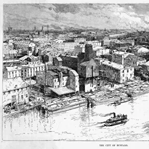
Photo Mug : Map of Buffalo and the Niagara Frontier, c.1900 (engraving)
")
")

![]()
Home Decor From Fine Art Finder
Map of Buffalo and the Niagara Frontier, c.1900 (engraving)
532728 Map of Buffalo and the Niagara Frontier, c.1900 (engraving); (add.info.: Map of Buffalo, New York, and the Niagara Frontier, circa 1900, from the 10th edition of Encyclopaedia Britannica.); Encyclopaedia Britannica/UIG
Media ID 38140576
© Encyclopaedia Britannica/UIG / Bridgeman Images
1900 19th Century Style Boundary Buffalo City Map Direction Geographical Border Guidance Illustration Technique Lake Erie Navigational Equipment New York State Niagara River Number Old Fashioned Physical Geography The Past Western Script Canadians Ontario Canada
Photo Mug
Sip your morning coffee in style with our Photo Mug featuring a vintage engraving of the Map of Buffalo and the Niagara Frontier from 1900. Perfect for history buffs and art lovers alike!
A personalised photo mug blends sentimentality with functionality, making an ideal gift for cherished loved ones, close friends, or valued colleagues. Preview may show both sides of the same mug.
Elevate your coffee or tea experience with our premium white ceramic mug. Its wide, comfortable handle makes drinking easy, and you can rely on it to be both microwave and dishwasher safe. Sold in single units, preview may show both sides of the same mug so you can see how the picture wraps around.
Mug Size is 9.6cm high x 8.1cm diameter (3.8" x 3.2")
These are individually made so all sizes are approximate
FEATURES IN THESE COLLECTIONS
> Fine Art Finder
> Temp Classification
> Maps and Charts
> Related Images
> North America
> Canada
> Lakes
> Lake Erie
> North America
> Canada
> Lakes
> Lake Ontario
> North America
> Canada
> Lakes
> Related Images
> North America
> Canada
> Maps
> North America
> Canada
> Related Images
> North America
> United States of America
> Lakes
> Lake Erie
> North America
> United States of America
> Lakes
> Lake Ontario
> North America
> United States of America
> Lakes
> Related Images
EDITORS COMMENTS
This vintage engraving of a Map of Buffalo and the Niagara Frontier from around 1900 is a fascinating glimpse into the past. The intricate details and old-fashioned style transport us back to a time when cartography was both an art and a science.
The map showcases the city of Buffalo, New York, as well as the surrounding area including Lake Erie and the Niagara River. It serves as a historical record of geographical boundaries, navigational routes, and physical geography in this region during the turn of the century.
As we study this map, we can imagine explorers using it for guidance on their journeys through North America. The Western script used to label landmarks adds to its charm and authenticity.
Despite being over a century old, this map remains relevant today for historians, geographers, and anyone interested in the history of Buffalo and its surroundings. It offers valuable insights into how cities were laid out in the past and how they have evolved over time.
Whether you're a Canadian or American citizen, this Map of Buffalo is sure to pique your curiosity about the rich history of this region. Display it proudly in your home or office as a conversation piece that sparks interest in exploration and discovery.
MADE IN AUSTRALIA
Safe Shipping with 30 Day Money Back Guarantee
FREE PERSONALISATION*
We are proud to offer a range of customisation features including Personalised Captions, Color Filters and Picture Zoom Tools
SECURE PAYMENTS
We happily accept a wide range of payment options so you can pay for the things you need in the way that is most convenient for you
* Options may vary by product and licensing agreement. Zoomed Pictures can be adjusted in the Basket.