Poster Print > Europe > United Kingdom > England > London > Towns > Welling
Poster Print : Old County Map of Wiltshire 1836 by Thomas Moule


![]()
Poster Prints from MapSeeker
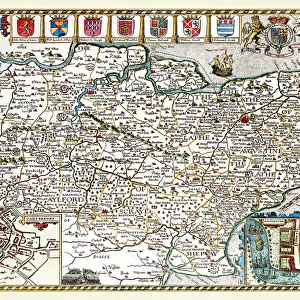
Old County Map of Wiltshire 1836 by Thomas Moule
This is a fine decorative reproduction County Map of Wiltshire from the First Edition series of Thomas Moule Maps, originally Published in 1836. The well-known series of County Maps which are known as Moules feature beautiful vignette views and were first published in separate sections for each county in 1830-32, they were then published in collected form in a two-volume work: The English Counties Delineated: or a Topographical Description of England: Illustrated by a Complete Series of County Maps by Thomas Moule: London: Published by George Virtue 1836
Welcome to the Mapseeker Image library and enter an historic gateway to one of the largest on-line collections of Historic Maps, Nostalgic Views, Vista's and Panorama's from a World gone by.
Media ID 20348106
© Mapseeker Publishing Ltd
County Map County Map Of England English County Map Historic Map Moule Map Old County Map Old English County Map Old Moule Map Thomas Moule Thomas Moule Map Wiltshire
A4 (29.7 x 21cm) Poster Print
Step back in time with our exquisite Old County Map of Wiltshire 1836 by Thomas Moule. This finely detailed reproduction, sourced from the First Edition series of Thomas Moule Maps, originally published in 1836, showcases the rich history and geography of Wiltshire as it was over 180 years ago. Meticulously crafted by Thomas Moule and George Virtue for MapSeeker, this vintage map print is a must-have for history enthusiasts, antique collectors, and those who appreciate the beauty of traditional cartography. Bring a touch of the past into your home or office with this captivating and decorative addition to your wall.
Premium quality poster prints are printed on luxurious semi-gloss satin 270 gsm paper. Our meticulously crafted poster prints offer an affordable option for decorating any space, making them ideal for living rooms, bedrooms, offices and beyond. To ensure your poster arrives in good condition, we roll and send them in strong mailing tubes.
Poster prints are budget friendly enlarged prints in standard poster paper sizes (A0, A1, A2, A3 etc). Whilst poster paper is sometimes thinner and less durable than our other paper types, they are still ok for framing and should last many years. Our Archival Quality Photo Prints and Fine Art Paper Prints are printed on higher quality paper and the choice of which largely depends on your budget.
Estimated Product Size is 21.6cm x 30.3cm (8.5" x 11.9")
These are individually made so all sizes are approximate
Artwork printed orientated as per the preview above, with portrait (vertical) orientation to match the source image.
FEATURES IN THESE COLLECTIONS
> MapSeeker
> Maps from the British Isles
> England and Counties PORTFOLIO
> Arts
> Artists
> M
> Thomas Moule
> Europe
> United Kingdom
> England
> London
> Towns
> Welling
> Europe
> United Kingdom
> England
> Maps
> Europe
> United Kingdom
> England
> Wells
> Europe
> United Kingdom
> England
> Wiltshire
> Related Images
> Maps and Charts
> Related Images
EDITORS COMMENTS
This exquisite print showcases the "Old County Map of Wiltshire 1836" by Thomas Moule, a renowned cartographer of his time. Originally published as part of the first edition series in 1836, this decorative reproduction captures the charm and historical significance of Moule's work. Moule's county maps are widely recognized for their intricate vignette views and attention to detail. The map of Wiltshire is no exception, offering a fascinating glimpse into the past. It was initially released in separate sections for each county between 1830-32 before being compiled into a two-volume masterpiece titled "The English Counties Delineated: or a Topographical Description of England". Published by George Virtue in London, this particular edition from 1836 holds immense value for history enthusiasts and collectors alike. Its depiction of Wiltshire provides an invaluable resource for studying the region's development over time. With its vintage aesthetic and rich historical context, this old English county map serves as both an artistic centerpiece and an educational tool. Whether displayed in homes or offices, it adds character to any space while sparking conversations about local heritage. Thomas Moule's contribution to cartography cannot be overstated, making this print not just a beautiful piece but also a tribute to his remarkable talent. Transport yourself back to early nineteenth-century England with this historic map that immortalizes Wiltshire's unique identity within the larger tapestry of British counties.
MADE IN AUSTRALIA
Safe Shipping with 30 Day Money Back Guarantee
FREE PERSONALISATION*
We are proud to offer a range of customisation features including Personalised Captions, Color Filters and Picture Zoom Tools
SECURE PAYMENTS
We happily accept a wide range of payment options so you can pay for the things you need in the way that is most convenient for you
* Options may vary by product and licensing agreement. Zoomed Pictures can be adjusted in the Cart.