Poster Print > Arts > Artists > B > Jan Blaeu
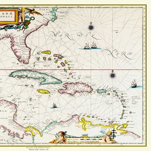
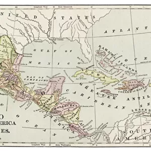
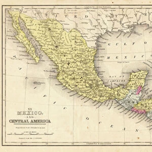
Poster Print : Atlas Novus, 17th c Map of the Caribbean


![]()
Poster Prints from Mary Evans Picture Library
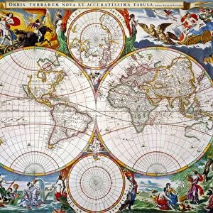
Atlas Novus, 17th c Map of the Caribbean
BLAEU, Jan (1596-1673). Atlas Novus or Atlas Maior. 1635 - 1665. Insulae Americanae in Oceano Septentrionali cum Terris Adiacentibus. Map of the Caribbean islands printed in Amsterdam circa 1645
Mary Evans Picture Library makes available wonderful images created for people to enjoy over the centuries
Media ID 14179456
© Iberfoto/Mary Evans
1571 1596 1635 1638 1645 1665 1673 Amsterdam Antillean Antilles Atlas Blaeu Caribbean Cuba Cuban Cubans Geographic Geographical Geography Honduran Honduras Indies Janszoon Maior Mejico Mexican Mexicans Mexico Monde Novus Willem Caribbeans Insulae
A4 (29.7 x 21cm) Poster Print
Discover the captivating history of the Caribbean with our exquisite selection of poster prints from Media Storehouse. Featuring the intricately detailed "Atlas Novus, 16th Century Map of the Caribbean" by Jan Blaeu, this vintage map brings the rich maritime history of the Caribbean to life. Printed from the original plate sourced from Mary Evans Prints Online, this poster is an authentic piece of cartographic art. Each print is produced using high-quality materials and state-of-the-art printing techniques to ensure a stunning, vibrant image that will be a beautiful addition to any room in your home or office. Travel back in time and explore the Caribbean as it was depicted in the 17th century with this captivating piece of historical artwork.
Premium quality poster prints are printed on luxurious semi-gloss satin 270 gsm paper. Our meticulously crafted poster prints offer an affordable option for decorating any space, making them ideal for living rooms, bedrooms, offices and beyond. To ensure your poster arrives in good condition, we roll and send them in strong mailing tubes.
Poster prints are budget friendly enlarged prints in standard poster paper sizes (A0, A1, A2, A3 etc). Whilst poster paper is sometimes thinner and less durable than our other paper types, they are still ok for framing and should last many years. Our Archival Quality Photo Prints and Fine Art Paper Prints are printed on higher quality paper and the choice of which largely depends on your budget.
Estimated Product Size is 30.3cm x 21.6cm (11.9" x 8.5")
These are individually made so all sizes are approximate
Artwork printed orientated as per the preview above, with landscape (horizontal) or portrait (vertical) orientation to match the source image.
FEATURES IN THESE COLLECTIONS
> Arts
> Artists
> B
> Jan Blaeu
> Arts
> Artists
> B
> Willem Blaeu
> Maps and Charts
> Related Images
> Maps and Charts
> Willem Janszoon Blaeu
> Maps and Charts
> World
> North America
> Cuba
> Maps
> North America
> Cuba
> Related Images
> North America
> Honduras
> Maps
> North America
> Honduras
> Related Images
> North America
> Mexico
> Maps
> North America
> Mexico
> Related Images
EDITORS COMMENTS
This stunning 17th century map, titled "Atlas Novus" or "Atlas Maior," showcases the Caribbean islands and surrounding territories as depicted by the renowned Dutch cartographer Jan Blaeu. Printed in Amsterdam around 1645, this map is a testament to the extensive geographical knowledge of the time. The map is part of Blaeu's larger work, "Theatrum Orbis Terrarum," which was first published in 1635 and continued to be updated until 1665. The map, which covers the western hemisphere from the eastern coast of South America to the eastern seaboard of North America, is rich in detail. It includes the Caribbean islands, which are labeled in both Latin and their indigenous names, as well as the coastlines of Central and South America. The map also features various annotations, such as the locations of major ports, cities, and other points of interest. Blaeu, who was born in Alkmaar, Netherlands, in 1596, was a prominent figure in the world of cartography during the Dutch Golden Age. He was the son of Willem Blaeu, who founded the Blaeu cartographic publishing house in Amsterdam in 1598. Jan Blaeu continued the family business after his father's death in 1638, and his maps were known for their high-quality production and meticulous detail. This map, in particular, is a valuable historical document that provides insight into the geographical knowledge of the Caribbean and the wider world during the 17th century. It is also a beautiful work of art, with intricate cartouches and decorative elements that add to its visual appeal. The map is a reminder of the fascination that Europeans had with the New World and the desire to explore and chart its vast territories.
MADE IN AUSTRALIA
Safe Shipping with 30 Day Money Back Guarantee
FREE PERSONALISATION*
We are proud to offer a range of customisation features including Personalised Captions, Color Filters and Picture Zoom Tools
SECURE PAYMENTS
We happily accept a wide range of payment options so you can pay for the things you need in the way that is most convenient for you
* Options may vary by product and licensing agreement. Zoomed Pictures can be adjusted in the Cart.