Canvas Print > Europe > United Kingdom > England > London > Politics > Frederick North
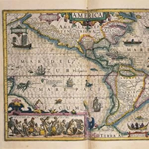
Canvas Print : Map of the Americas, 1660


![]()
Canvas Prints from Science Photo Library
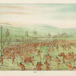
Map of the Americas, 1660
17th century map of the Americas. Published in Amsterdam in 1660, this map by the Dutch cartographer Frederick de Witt (1630-1706) shows the geography of the Americas, the New World being explored by Europeans. The exploration of South America was well advanced by this stage, but large swathes of North America had yet to be mapped. The artworks across top show various cities, from left to right: Cusco (Peru); Tenochtitlan (labelled Mexico, now Mexico City); Olinda (Brazil); Havana (Cuba); San Domingo (Hispaniola); and Cartagena (Colombia). The artworks at left and right show natives of Virginia (north-eastern North America), Chile and Brazil, and the Magellanic people of Patagonia
Science Photo Library features Science and Medical images including photos and illustrations
Media ID 1699849
© LIBRARY OF CONGRESS, GEOGRAPHY AND MAP DIVISION/SCIENCE PHOTO LIBRARY
1600s 1660 17th Century Age Of Discovery Brazil Caribbean Cartography Chile Cities City Colonies Colony Continent Continental Continents Dutch Empire Exploration French Hispaniola Medieval Mexico City Middle Ages Native Natives New World North American South America South American Spanish Virginia Cartagena Cusco Havana Olinda San Domingo Tenochtitlan
20"x16" (51x41cm) Canvas Print
"Step back in time with our captivating Canvas Print of the "Map of the Americas, 1660" by Science Photo Library. This exquisite piece of historical art showcases the intricate cartography of the 17th century, as depicted in this rare and fascinating map published in Amsterdam. Created by the Dutch cartographer Frederick de Witt, this masterpiece provides a glimpse into the geographical knowledge of the time, featuring detailed representations of the Americas as they were known during the 1600s. Elevate your home or office décor with this beautiful and educational canvas print, sure to spark conversation and inspire a sense of wonder."
Delivered stretched and ready to hang our premium quality canvas prints are made from a polyester/cotton blend canvas and stretched over a 1.25" (32mm) kiln dried knot free wood stretcher bar. Packaged in a plastic bag and secured to a cardboard insert for safe transit.
Canvas Prints add colour, depth and texture to any space. Professionally Stretched Canvas over a hidden Wooden Box Frame and Ready to Hang
Estimated Product Size is 50.8cm x 40.6cm (20" x 16")
These are individually made so all sizes are approximate
Artwork printed orientated as per the preview above, with landscape (horizontal) orientation to match the source image.
FEATURES IN THESE COLLECTIONS
> Arts
> Art Movements
> Medieval Art
> Europe
> Spain
> Related Images
> Europe
> United Kingdom
> England
> London
> Politics
> Frederick North
> Maps and Charts
> Early Maps
> Maps and Charts
> Related Images
> Science Photo Library
> History
EDITORS COMMENTS
This print takes us back to the 17th century, immersing us in the age of exploration and colonialism. Published in Amsterdam in 1660 by Dutch cartographer Frederick de Witt, this map of the Americas offers a glimpse into how Europeans perceived and navigated the New World. While South America had been extensively explored at this point, large portions of North America remained uncharted. The top section of the map showcases stunning artworks depicting various cities that were significant during that time. From left to right, we see Cusco (Peru), Tenochtitlan (now Mexico City), Olinda (Brazil), Havana (Cuba), San Domingo (Hispaniola), and Cartagena (Colombia). These vibrant illustrations provide a visual representation of the diverse cultures and settlements across these regions. To further enrich our understanding, portraits on both sides depict natives from different parts of the Americas: Virginia in northeastern North America, Chile, Brazil, and even the Magellanic people from Patagonia. These images offer glimpses into their lives during this period of history. As we explore this remarkable map print, it serves as a reminder of an era marked by discovery and conquest. It allows us to appreciate how far our knowledge has evolved since then while also acknowledging its historical significance. This piece is not just a mere depiction; it's an invitation to delve into centuries past when continents were still being charted and new worlds awaited exploration.
MADE IN AUSTRALIA
Safe Shipping with 30 Day Money Back Guarantee
FREE PERSONALISATION*
We are proud to offer a range of customisation features including Personalised Captions, Color Filters and Picture Zoom Tools
SECURE PAYMENTS
We happily accept a wide range of payment options so you can pay for the things you need in the way that is most convenient for you
* Options may vary by product and licensing agreement. Zoomed Pictures can be adjusted in the Cart.