Cushion > Animals > Mammals > Cricetidae > Meridionalis
Cushion : 17th century map of South America


![]()
Home Decor from Science Photo Library
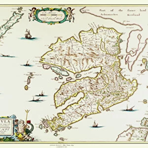
17th century map of South America
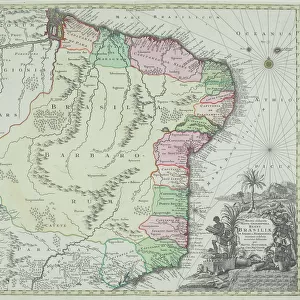
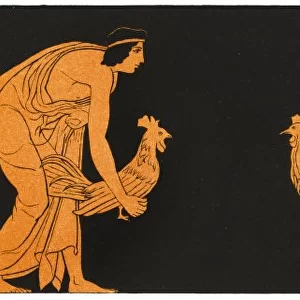
South America, 17th century Dutch map. This shows the new continent that was being discovered by European explorers. The shape is distorted because it had not yet been accurately mapped. Two large rivers in Brazil are shown flowing from a large lake in eastern Brazil. The western coastline is by now fairly accurately mapped, but it was still not realised that Tierra del Fuego (bottom centre) in the Straits of Magellan, was a group of islands and not part of a large southern continent. The inset at lower left shows the Incan city of Cuzco in Peru. This map, published around 1630 by Jodocus Hondius, continued the earlier work of Gerard Mercator
Science Photo Library features Science and Medical images including photos and illustrations
Media ID 6350551
© GEORGETTE DOUWMA/SCIENCE PHOTO LIBRARY
17th Century Aboriginal Age Of Discovery Ancient Cartography City Civilization Distorted Distortion Dutch Earth Science Exploration Exploring Illustrated Inaccurate Inca Incan Incomplete Latin Mapping Maps Mercator New World Sciences Seventeenth South America Tierra Del Fuego 1630 Cuzco Gerard Gerardus Hondius Jodocus Native Americans
Cushion
Refresh your home decor with a beautiful full photo 16"x16" (40x40cm) cushion, complete with cushion pad insert. Printed on both sides and made from 100% polyester with a zipper on the bottom back edge of the cushion cover. Care Instructions: Warm machine wash, do not bleach, do not tumble dry. Warm iron inside out. Do not dry clean.
Accessorise your space with decorative, soft cushions
Estimated Product Size is 40cm x 40cm (15.7" x 15.7")
These are individually made so all sizes are approximate
Artwork printed orientated as per the preview above, with landscape (horizontal) or portrait (vertical) orientation to match the source image.
FEATURES IN THESE COLLECTIONS
> Animals
> Fishes
> G
> Grouper
> Animals
> Mammals
> Cricetidae
> Meridionalis
> Animals
> Mammals
> Muridae
> Western Mouse
> Animals
> Mammals
> Sciuridae
> Meridionalis
> Arts
> Artists
> H
> Jodocus Hondius
> Arts
> Artists
> M
> Gerardus Mercator
> Arts
> Landscape paintings
> Waterfall and river artworks
> River artworks
> Historic
> Ancient civilizations
> Inca Civilization
> Ancient civilizations
> Historic
> Ancient civilizations
> Inca Civilization
> Historic
> Ancient civilizations
> Maps and Charts
> Gerardus Mercator's Cartographic
EDITORS COMMENTS
This print showcases a 17th-century Dutch map of South America, shedding light on the era of European exploration and discovery. The distorted shape of the continent reflects the limited accuracy in mapping during that time. Notably, two prominent rivers in Brazil are depicted as flowing from a large lake in eastern Brazil, while the western coastline is relatively well-mapped. However, it was not yet realized that Tierra del Fuego, situated at the bottom center within the Straits of Magellan, actually comprised a group of islands rather than part of a larger southern continent. The inset at lower left offers an intriguing glimpse into Incan civilization with an illustration depicting Cuzco, an ancient city located in Peru. Published around 1630 by Jodocus Hondius and building upon earlier work by Gerard Mercator, this map represents an important milestone in cartography during the Age of Discovery. While incomplete and inaccurate by modern standards due to limited knowledge about native peoples and geography at that time, this historic artwork serves as a testament to humanity's relentless pursuit of knowledge and understanding. It invites us to appreciate how far we have come since then in unraveling Earth's mysteries through advancements in earth science and mapping techniques.
MADE IN AUSTRALIA
Safe Shipping with 30 Day Money Back Guarantee
FREE PERSONALISATION*
We are proud to offer a range of customisation features including Personalised Captions, Color Filters and Picture Zoom Tools
SECURE PAYMENTS
We happily accept a wide range of payment options so you can pay for the things you need in the way that is most convenient for you
* Options may vary by product and licensing agreement. Zoomed Pictures can be adjusted in the Cart.