Fine Art Print > Arts > Artists > S > John Speed
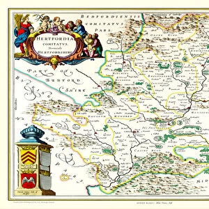
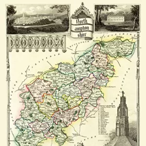
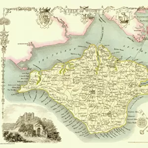
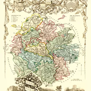
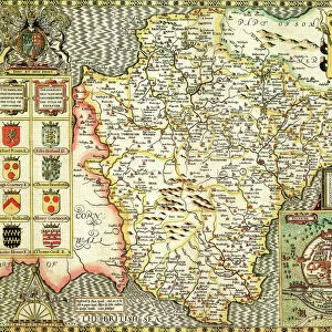
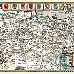
Fine Art Print : Old County Map of Hertfordshire 1611 by John Speed


![]()
Fine Art Prints from MapSeeker
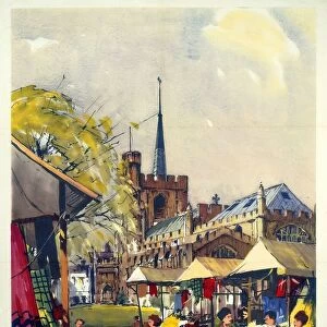
Old County Map of Hertfordshire 1611 by John Speed
A facimile of John Speeds historical map of Hertfordshire originally published for the " Theatre of the Empire of Great Britain", an atlas to accompany " a history of Great Britain"
Welcome to the Mapseeker Image library and enter an historic gateway to one of the largest on-line collections of Historic Maps, Nostalgic Views, Vista's and Panorama's from a World gone by.
Media ID 20347552
© Mapseeker Publishing Ltd
County Map County Map Of England English County Map Historic Map John Speed Map Old County Map Old English County Map Speed Map Speede Map Hertfordshire
21"x14" (+3" Border) Fine Art Print
Discover the rich history of Hertfordshire with our exquisite Old County Map of Hertfordshire 1611 by John Speed from our Media Storehouse Fine Art Prints collection. This stunning facsimile, taken from the original map published for the "Theatre of the Empire of Great Britain," transports you back in time with intricate detail and vibrant colors. Bring the historical charm of this ancient county into your home or office, and add a touch of timeless beauty to your space. Perfect for history enthusiasts, collectors, or anyone who appreciates the art of cartography.
21x14 image printed on 27x20 Fine Art Rag Paper with 3" (76mm) white border. Our Fine Art Prints are printed on 300gsm 100% acid free, PH neutral paper with archival properties. This printing method is used by museums and art collections to exhibit photographs and art reproductions.
Our fine art prints are high-quality prints made using a paper called Photo Rag. This 100% cotton rag fibre paper is known for its exceptional image sharpness, rich colors, and high level of detail, making it a popular choice for professional photographers and artists. Photo rag paper is our clear recommendation for a fine art paper print. If you can afford to spend more on a higher quality paper, then Photo Rag is our clear recommendation for a fine art paper print.
Estimated Image Size (if not cropped) is 53.3cm x 35.5cm (21" x 14")
Estimated Product Size is 68.6cm x 50.8cm (27" x 20")
These are individually made so all sizes are approximate
Artwork printed orientated as per the preview above, with landscape (horizontal) orientation to match the source image.
FEATURES IN THESE COLLECTIONS
> Arts
> Artists
> S
> John Speed
> Europe
> United Kingdom
> England
> Hertfordshire
> Related Images
> Europe
> United Kingdom
> England
> Maps
> Maps and Charts
> British Empire Maps
> Maps and Charts
> Early Maps
> Maps and Charts
> Related Images
> MapSeeker
> Maps from the British Isles
> England and Counties PORTFOLIO
EDITORS COMMENTS
This print showcases the intricate details of an "Old County Map of Hertfordshire 1611" by John Speed. As a faithful reproduction of Speed's historical map, originally published for the "Theatre of the Empire of Great Britain" this piece offers a fascinating glimpse into the past. With its elegant design and meticulous craftsmanship, this English county map takes us back to a time when cartography was both an art form and a means to understand one's surroundings. The delicate lines and ornate lettering transport us to 17th-century Hertfordshire, inviting us to explore its rich history. John Speed's expertise in mapping is evident as he presents not only geographical features but also important landmarks and settlements within Hertfordshire. This historic map serves as more than just a visual representation; it acts as a portal through which we can delve into the region's cultural heritage. Whether you are an avid historian or simply appreciate beautiful artwork, this old county map will surely captivate your imagination. It allows you to trace the evolution of Hertfordshire over centuries while providing valuable insights into England's past. Displaying this stunning facsimile in your home or office will undoubtedly spark conversations about local history and geography. Let yourself be transported through time with this remarkable piece that pays homage to John Speed's enduring legacy in cartography.
MADE IN AUSTRALIA
Safe Shipping with 30 Day Money Back Guarantee
FREE PERSONALISATION*
We are proud to offer a range of customisation features including Personalised Captions, Color Filters and Picture Zoom Tools
SECURE PAYMENTS
We happily accept a wide range of payment options so you can pay for the things you need in the way that is most convenient for you
* Options may vary by product and licensing agreement. Zoomed Pictures can be adjusted in the Cart.