Fine Art Print > Aerial Photography > Africa
Fine Art Print : Eurasia, topographic map


![]()
Fine Art Prints from Science Photo Library
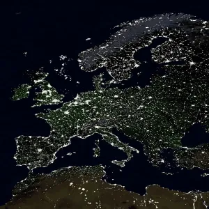
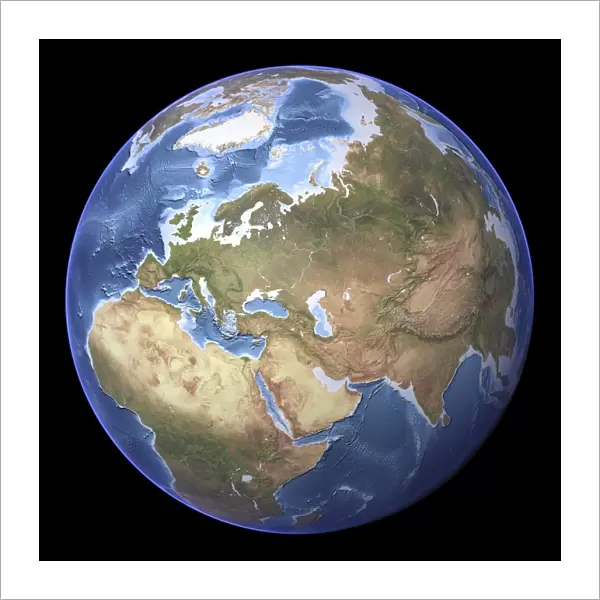
Eurasia, topographic map
Eurasia, topographic map. This map is centred on Russia, with Europe at centre left and East Asia at right. The North Pole (upper left), with Greenland shown in white, and Africa (lower left) are also seen. The seabed depth varies from shallow (light blue) on the continental shelves, to deep ocean basins (dark blue). Highlands and lowlands of the continents are shown as ridges and flat areas. Topographic and bathymetric data is usually gathered by using aerial and satellite imagery combined with radar and sonar mapping
Science Photo Library features Science and Medical images including photos and illustrations
Media ID 1705043
© PLANETARY VISIONS LTD/SCIENCE PHOTO LIBRARY
Africa Altimetric Altimetry Arctic Arctic Ocean Atlantic Ocean Basin Bathymetric Bathymetry Circle Circular Combined Data Continent Continental Shelf Continents Data Depth Depths East Asia Eurasia Floor Globe Greenland Highlands Indian Ocean Land Lowlands Mapped Mountains North Pole Oceanic Oceanographic Oceanography Physical Geography Plains Polar Radar Region Ridge Round Russia Satellite Satellite Image Sea Bed Sea Floor Shelves Sonar Mapping Sonic Sphere Spherical Topographic Topography World
20"x20" (+3" Border) Fine Art Print
Discover the breathtaking beauty of our world with Media Storehouse's Fine Art Prints. This exquisite piece features a topographic map of Eurasia, meticulously captured by the experts at Science Photo Library. With Russia at the heart, Europe to the left and East Asia to the right, this map transports you on a journey across continents. The intricate details of the terrain, from the snow-capped peaks of the North Pole to the vast expanses of green in Europe, are brought to life in stunning clarity. Add this unique and captivating print to your home or office space and let the wonders of Eurasia inspire you every day.
20x20 image printed on 26x26 Fine Art Rag Paper with 3" (76mm) white border. Our Fine Art Prints are printed on 300gsm 100% acid free, PH neutral paper with archival properties. This printing method is used by museums and art collections to exhibit photographs and art reproductions.
Our fine art prints are high-quality prints made using a paper called Photo Rag. This 100% cotton rag fibre paper is known for its exceptional image sharpness, rich colors, and high level of detail, making it a popular choice for professional photographers and artists. Photo rag paper is our clear recommendation for a fine art paper print. If you can afford to spend more on a higher quality paper, then Photo Rag is our clear recommendation for a fine art paper print.
Estimated Image Size (if not cropped) is 50.8cm x 50.8cm (20" x 20")
Estimated Product Size is 66cm x 66cm (26" x 26")
These are individually made so all sizes are approximate
Artwork printed orientated as per the preview above, with landscape (horizontal) or portrait (vertical) orientation to match the source image.
FEATURES IN THESE COLLECTIONS
> Aerial Photography
> Related Images
> Africa
> Related Images
> Animals
> Mammals
> Cats (Domestic)
> Russian Blue
> Animals
> Mammals
> Cats (Domestic)
> Russian White
> Animals
> Mammals
> Muridae
> Plains Mouse
> Arts
> Artists
> O
> Oceanic Oceanic
> Asia
> Related Images
> Europe
> France
> Canton
> Landes
> Science Photo Library
> Aerial and Satellite
EDITORS COMMENTS
This print showcases a detailed topographic map of Eurasia, with Russia at its center. The vastness of this continent is beautifully depicted, as Europe occupies the left side while East Asia stretches out on the right. This comprehensive map also includes other significant regions such as Africa and Greenland. The varying depths of the seabed are represented by shades of blue, ranging from light hues near the continental shelves to darker tones in deep ocean basins. To gather this valuable data, a combination of aerial and satellite imagery, along with radar and sonar mapping techniques were employed. The contours on the map reveal both highlands and lowlands across different continents, creating an intricate network of ridges and flat areas. As we explore this visual representation, it becomes evident that our planet's geography is truly diverse and awe-inspiring. With its circular shape resembling a globe, this print serves as a reminder that Earth is an interconnected sphere where landmasses seamlessly blend into marine environments. It highlights not only the physical features but also emphasizes how crucial it is to understand our world's topography for scientific research purposes. This remarkable image has been captured by Science Photo Library—an expert in providing exceptional visuals related to various scientific fields—making it an invaluable addition for anyone interested in geography or oceanography.
MADE IN AUSTRALIA
Safe Shipping with 30 Day Money Back Guarantee
FREE PERSONALISATION*
We are proud to offer a range of customisation features including Personalised Captions, Color Filters and Picture Zoom Tools
SECURE PAYMENTS
We happily accept a wide range of payment options so you can pay for the things you need in the way that is most convenient for you
* Options may vary by product and licensing agreement. Zoomed Pictures can be adjusted in the Cart.