Framed Print > Europe > United Kingdom > England > London > Towns > Welling
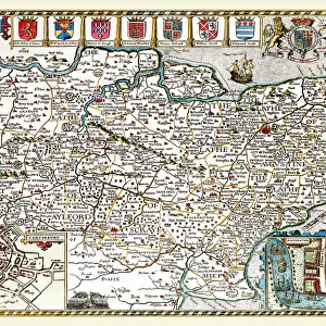
Framed Print : Old County Map of Westmoreland 1836 by Thomas Moule


![]()
Framed Photos from MapSeeker
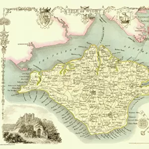
Old County Map of Westmoreland 1836 by Thomas Moule
This is a fine decorative reproduction County Map of Westmoreland from the First Edition series of Thomas Moule Maps, originally Published in 1836. The well-known series of County Maps which are known as Moules feature beautiful vignette views and were first published in separate sections for each county in 1830-32, they were then published in collected form in a two-volume work: The English Counties Delineated: or a Topographical Description of England: Illustrated by a Complete Series of County Maps by Thomas Moule: London: Published by George Virtue 1836
Welcome to the Mapseeker Image library and enter an historic gateway to one of the largest on-line collections of Historic Maps, Nostalgic Views, Vista's and Panorama's from a World gone by.
Media ID 20348090
© Mapseeker Publishing Ltd
County Map County Map Of England English County Map Historic Map Moule Map Old County Map Old English County Map Old Moule Map Thomas Moule Thomas Moule Map Westmoreland
13.5"x11.5" (34x29cm) Premium Frame
Adorn your home or office with a piece of historical charm with our Media Storehouse Framed Print of the Old County Map of Westmoreland 1836 by Thomas Moule. This exquisite reproduction is taken from the First Edition series of Thomas Moule Maps, originally published in 1836 by Thomas Moule and George Virtue from MapSeeker. The intricate details of this antique map showcase the historical boundaries, topography, and places of interest in Westmoreland County during that era. Each print comes in a high-quality frame, making it a perfect addition to any decor. Travel back in time and add a touch of history to your space with this beautiful framed print.
Framed and mounted 9x7 print. Professionally handmade full timber moulded frames are finished off with framers tape and come with a hanging solution on the back. Outer dimensions are 13.5x11.5 inches (34x29cm). Quality timber frame frame moulding (20mm wide and 30mm deep) with frame colours in your choice of black, white, or raw oak and a choice of black or white card mounts. Frames have a perspex front providing a virtually unbreakable glass-like finish which is easily cleaned with a damp cloth.
Contemporary Framed and Mounted Prints - Professionally Made and Ready to Hang
Estimated Image Size (if not cropped) is 21.4cm x 21.4cm (8.4" x 8.4")
Estimated Product Size is 34cm x 29.2cm (13.4" x 11.5")
These are individually made so all sizes are approximate
Artwork printed orientated as per the preview above, with landscape (horizontal) or portrait (vertical) orientation to match the source image.
FEATURES IN THESE COLLECTIONS
> Arts
> Artists
> M
> Thomas Moule
> Europe
> United Kingdom
> England
> London
> Towns
> Welling
> Europe
> United Kingdom
> England
> Maps
> Europe
> United Kingdom
> England
> Wells
> Maps and Charts
> Early Maps
> Maps and Charts
> Related Images
> MapSeeker
> Maps from the British Isles
> England and Counties PORTFOLIO
EDITORS COMMENTS
This exquisite print showcases the "Old County Map of Westmoreland 1836" by Thomas Moule, a renowned cartographer from the 19th century. Originally published as part of Moule's First Edition series in 1836, this decorative reproduction offers a glimpse into the rich history and topography of Westmoreland County. Moule's county maps are highly regarded for their intricate details and captivating vignette views. Each map was meticulously crafted to provide an accurate representation of England's counties, with Westmoreland being no exception. The map features charming illustrations that depict notable landmarks, countryside scenes, and architectural marvels. Originally released in separate sections for each county between 1830-32, these remarkable maps were later compiled into a two-volume work titled "The English Counties Delineated: or a Topographical Description of England". Published by George Virtue in London in 1836, this collection became highly sought after by both historians and enthusiasts alike. As you gaze upon this historic treasure, you can't help but appreciate its significance in preserving our past. This old county map serves as a window to another era—a testament to the artistry and dedication displayed by Thomas Moule. Whether you're an avid collector or simply captivated by history, this print is sure to transport you back in time to explore the enchanting landscapes and hidden gems of Westmoreland County.
MADE IN AUSTRALIA
Safe Shipping with 30 Day Money Back Guarantee
FREE PERSONALISATION*
We are proud to offer a range of customisation features including Personalised Captions, Color Filters and Picture Zoom Tools
SECURE PAYMENTS
We happily accept a wide range of payment options so you can pay for the things you need in the way that is most convenient for you
* Options may vary by product and licensing agreement. Zoomed Pictures can be adjusted in the Cart.