Home > North America > Dominican Republic > Dominican Republic Heritage Sites > Colonial City of Santo Domingo
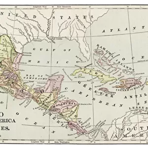
1800, Stockdale Map of Hispaniola or Santo Domingo, West Indies, Haiti, Dominican Republic

![]()
Wall Art and Photo Gifts from Liszt Collection
1800, Stockdale Map of Hispaniola or Santo Domingo, West Indies, Haiti, Dominican Republic
Liszt Collection of nineteenth-century engravings and images to browse and enjoy
Media ID 14004868
© Artokoloro Quint Lox Limited
1800 Dominican Republic Haiti West Indies Antique Map Atlas Chart Geographic Latitude Longitude Mappa Mundi Old Antique Plan Old Antique View Old Map Ols Antique Map Rare Old Maps Topo
FEATURES IN THESE COLLECTIONS
> Maps and Charts
> Early Maps
> Maps and Charts
> World
> North America
> Dominican Republic
> Dominican Republic Heritage Sites
> Colonial City of Santo Domingo
> North America
> Dominican Republic
> Maps
> North America
> Dominican Republic
> Santo Domingo
> North America
> Haiti
> Maps
EDITORS COMMENTS
This print showcases the intricate details of the 1800 Stockdale Map of Hispaniola or Santo Domingo, offering a glimpse into the rich history and geography of this enchanting region. The map encompasses both Haiti and the Dominican Republic, providing a comprehensive view of their topography, cartography, and land formations. With its vintage charm and ancient allure, this map is not just a mere illustration but rather an artistic representation that takes us back in time. Its carefully plotted grid lines reveal latitude and longitude coordinates, allowing for precise navigation across this fascinating landscape. As we explore this rare old map, we are transported to an era where discovery and exploration were at the forefront. It serves as a reminder of how our understanding of geographical regions has evolved over centuries. The aged paper texture adds to its historical significance while also enhancing its decorative appeal. This stunning piece from the Liszt Collection captures the essence of travel and adventure through its detailed depiction of Earth's diverse regions. Whether you are an avid collector or simply appreciate art with historical value, this antique map offers a unique opportunity to own a piece of world history. Let it serve as a conversation starter or be displayed proudly on your wall as you embark on your own journey through time.
MADE IN AUSTRALIA
Safe Shipping with 30 Day Money Back Guarantee
FREE PERSONALISATION*
We are proud to offer a range of customisation features including Personalised Captions, Color Filters and Picture Zoom Tools
SECURE PAYMENTS
We happily accept a wide range of payment options so you can pay for the things you need in the way that is most convenient for you
* Options may vary by product and licensing agreement. Zoomed Pictures can be adjusted in the Cart.