Framed Print > Granger Art on Demand > Maps
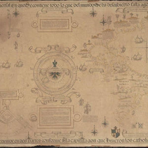
Framed Print : WALDSEEMULLER: WORLD MAP. Map of the world by Martin Waldseemuller and Laurens Fries


![]()
Framed Photos from Granger
WALDSEEMULLER: WORLD MAP. Map of the world by Martin Waldseemuller and Laurens Fries
WALDSEEMULLER: WORLD MAP. Map of the world by Martin Waldseemuller and Laurens Fries, printed at Strassburg in 1535, showing only a hint of the New World at left
Granger holds millions of images spanning more than 25,000 years of world history, from before the Stone Age to the dawn of the Space Age
Media ID 6622399
1535 Age Of Discovery Continent Elephant Lauren Laurens Martin New World Strassburg World Fries Waldseemuller
A2 Premium Frame with A3 Poster
Discover the rich history of cartography with our stunning Framed Prints featuring the "Waldseemuller World Map" by Martin Waldseemuller and Laurens Fries. This rare and intriguing map, printed in Strasbourg in 1535, is a testament to the early explorers' understanding of the world. With only a subtle hint of the New World at the left, this historic map is a captivating addition to any home or office. Bring a piece of the past into your present with our high-quality Framed Prints, expertly crafted to preserve the beauty and detail of this Granger Art on Demand masterpiece.
Premium Paradise Wooden Range A2 Premium Poster Frame (62x45cm) with A3 Poster (42x30cm) and mounted behind a white matt board to make your photo really stand out. FSC Certified and Rainforest Alliance Certified for environmental, social, and economic sustainably. High transparency tempered glass window with a smooth finished frame. Great for filling empty walls, decorating blank spaces, or creating eye-catching gallery walls. Frames arrive ready to hang. Sent with secure, protective packaging. Smooth wooden veneer mimics the real wood look and feel with ultra-durable scratch resistance tempered glass.
Contemporary Framed and Mounted Prints - Professionally Made and Ready to Hang
Estimated Image Size (if not cropped) is 40.4cm x 40.4cm (15.9" x 15.9")
Estimated Product Size is 62cm x 44.6cm (24.4" x 17.6")
These are individually made so all sizes are approximate
Artwork printed orientated as per the preview above, with landscape (horizontal) or portrait (vertical) orientation to match the source image.
EDITORS COMMENTS
This print showcases the iconic "WALDSEEMULLER: WORLD MAP" created by Martin Waldseemuller and Laurens Fries in 1535. A true masterpiece of the Renaissance era, this map offers a glimpse into the Age of Discovery and the expanding knowledge of our world during that time. Printed at Strassburg, this historic artifact reveals an intriguing blend of accuracy and speculation. The map portrays a continent-centric view with Europe taking center stage, while only hinting at the existence of the New World on its left side. This subtle inclusion reflects the limited understanding Europeans had about these uncharted territories during that period. The attention to detail is remarkable as intricate rivers meander across continents, symbolizing their importance for trade and exploration. Each stroke meticulously captures both geographical features and cultural nuances, showcasing Waldseemuller's expertise as a cartographer. As we gaze upon this print, we are transported back in time to an age where curiosity fueled expeditions across vast oceans in search of new lands and treasures. It serves as a testament to humanity's insatiable thirst for knowledge and discovery. With its rich historical significance, this print from Granger Art on Demand allows us to appreciate not only the beauty but also the profound impact that maps like these have had on shaping our understanding of our planet throughout history.
MADE IN AUSTRALIA
Safe Shipping with 30 Day Money Back Guarantee
FREE PERSONALISATION*
We are proud to offer a range of customisation features including Personalised Captions, Color Filters and Picture Zoom Tools
SECURE PAYMENTS
We happily accept a wide range of payment options so you can pay for the things you need in the way that is most convenient for you
* Options may vary by product and licensing agreement. Zoomed Pictures can be adjusted in the Cart.