Mouse Mat > Granger Art on Demand > Maps
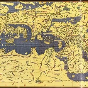
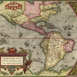
Mouse Mat : WALDSEEMULLER: WORLD MAP. Map of the world by Martin Waldseemuller and Laurens Fries


![]()
Home Decor from Granger
WALDSEEMULLER: WORLD MAP. Map of the world by Martin Waldseemuller and Laurens Fries
WALDSEEMULLER: WORLD MAP. Map of the world by Martin Waldseemuller and Laurens Fries, printed at Strassburg in 1535, showing only a hint of the New World at left
Granger holds millions of images spanning more than 25,000 years of world history, from before the Stone Age to the dawn of the Space Age
Media ID 6622399
1535 Age Of Discovery Continent Elephant Lauren Laurens Martin New World Strassburg World Fries Waldseemuller
Mouse Pad
Bring some life into your office, or create a heartfelt gift, with a personalised deluxe Mouse Mat. Made of high-density black foam with a tough, stain-resistant inter-woven cloth cover they will brighten up any home or corporate office.
Archive quality photographic print in a durable wipe clean mouse mat with non slip backing. Works with all computer mice
Estimated Product Size is 24.2cm x 19.7cm (9.5" x 7.8")
These are individually made so all sizes are approximate
Artwork printed orientated as per the preview above, with landscape (horizontal) or portrait (vertical) orientation to match the source image.
EDITORS COMMENTS
This print showcases the iconic "WALDSEEMULLER: WORLD MAP" created by Martin Waldseemuller and Laurens Fries in 1535. A true masterpiece of the Renaissance era, this map offers a glimpse into the Age of Discovery and the expanding knowledge of our world during that time. Printed at Strassburg, this historic artifact reveals an intriguing blend of accuracy and speculation. The map portrays a continent-centric view with Europe taking center stage, while only hinting at the existence of the New World on its left side. This subtle inclusion reflects the limited understanding Europeans had about these uncharted territories during that period. The attention to detail is remarkable as intricate rivers meander across continents, symbolizing their importance for trade and exploration. Each stroke meticulously captures both geographical features and cultural nuances, showcasing Waldseemuller's expertise as a cartographer. As we gaze upon this print, we are transported back in time to an age where curiosity fueled expeditions across vast oceans in search of new lands and treasures. It serves as a testament to humanity's insatiable thirst for knowledge and discovery. With its rich historical significance, this print from Granger Art on Demand allows us to appreciate not only the beauty but also the profound impact that maps like these have had on shaping our understanding of our planet throughout history.
MADE IN AUSTRALIA
Safe Shipping with 30 Day Money Back Guarantee
FREE PERSONALISATION*
We are proud to offer a range of customisation features including Personalised Captions, Color Filters and Picture Zoom Tools
SECURE PAYMENTS
We happily accept a wide range of payment options so you can pay for the things you need in the way that is most convenient for you
* Options may vary by product and licensing agreement. Zoomed Pictures can be adjusted in the Cart.