Jigsaw Puzzle > Europe > United Kingdom > England > Northamptonshire > Old
Jigsaw Puzzle : Old County Map of Northamptonshire 1611 by John Speed


![]()
Jigsaw Puzzles from MapSeeker
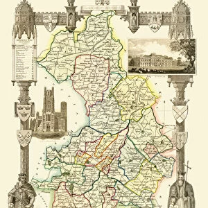
Old County Map of Northamptonshire 1611 by John Speed
A facimile of John Speeds historical map of Northamptonshire originally published for the " Theatre of the Empire of Great Britain", an atlas to accompany " a history of Great Britain"
Welcome to the Mapseeker Image library and enter an historic gateway to one of the largest on-line collections of Historic Maps, Nostalgic Views, Vista's and Panorama's from a World gone by.
Media ID 20348148
© Mapseeker Publishing Ltd
County Map County Map Of England English County Map Historic Map John Speed Map Old County Map Old English County Map Speed Map Speede Map
Jigsaw Puzzle (1000 Pieces)
Discover the rich history of Northamptonshire with our captivating Old County Map of Northamptonshire 1611 by John Speed. This intricately detailed jigsaw puzzle, inspired by the original map published for the "Theatre of the Empire of Great Britain," invites you on an engaging journey back in time. Explore the counties historic landmarks, castles, and villages as you piece together this beautifully illustrated puzzle. Perfect for puzzle enthusiasts, history buffs, or anyone seeking a challenging and rewarding activity. Immerse yourself in the past and create a treasure to display with the Media Storehouse Old County Map of Northamptonshire 1611 by John Speed jigsaw puzzle.
1000 piece puzzles are custom made in Australia and hand-finished on 100% recycled 1.6mm thick laminated puzzle boards. There is a level of repetition in jigsaw shapes with each matching piece away from its pair. The completed puzzle measures 76x50cm and is delivered packaged in an attractive presentation box specially designed to fit most mail slots with a unique magnetic lid
Jigsaw Puzzles are an ideal gift for any occasion
Estimated Product Size is 76cm x 50.2cm (29.9" x 19.8")
These are individually made so all sizes are approximate
Artwork printed orientated as per the preview above, with landscape (horizontal) or portrait (vertical) orientation to match the source image.
FEATURES IN THESE COLLECTIONS
> Arts
> Artists
> S
> John Speed
> Europe
> United Kingdom
> England
> Maps
> Europe
> United Kingdom
> England
> Northamptonshire
> Old
> Europe
> United Kingdom
> England
> Northamptonshire
> Related Images
> Maps and Charts
> British Empire Maps
> Maps and Charts
> Early Maps
> Maps and Charts
> Related Images
> MapSeeker
> Maps from the British Isles
> England and Counties PORTFOLIO
EDITORS COMMENTS
This stunning print showcases the intricate details of the "Old County Map of Northamptonshire 1611" by John Speed. A true masterpiece, this facsimile captures the essence of Speed's historical map originally published for the "Theatre of the Empire of Great Britain". As an atlas accompanying a comprehensive history of Great Britain, this map offers a fascinating glimpse into Northamptonshire's past. With its elegant design and meticulous craftsmanship, this old English county map transports us back in time to a bygone era. Every line and contour tells a story, revealing the rich heritage and cultural significance of Northamptonshire. From its charming villages to its majestic castles, every corner is meticulously depicted with utmost precision. John Speed's expertise as both a cartographer and historian shines through in this remarkable piece. The intricately drawn boundaries showcase not only Northamptonshire but also neighboring counties, providing context within England's broader geography. Whether you are an avid collector or simply appreciate historical artifacts, this print is sure to captivate your imagination. It serves as a window into our past while adding sophistication and charm to any space it graces. Displaying this iconic representation of Northamptonshire's history will undoubtedly spark conversations about our shared heritage and ignite curiosity about centuries long gone.
MADE IN AUSTRALIA
Safe Shipping with 30 Day Money Back Guarantee
FREE PERSONALISATION*
We are proud to offer a range of customisation features including Personalised Captions, Color Filters and Picture Zoom Tools
SECURE PAYMENTS
We happily accept a wide range of payment options so you can pay for the things you need in the way that is most convenient for you
* Options may vary by product and licensing agreement. Zoomed Pictures can be adjusted in the Cart.