Home > Arts > Artists > M > Gerardus Mercator
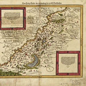
16th century world map

![]()
Wall Art and Photo Gifts from Science Photo Library
16th century world map
World map. 16th century Dutch map of the western (left) and eastern (right) hemispheres of Earth. This shows the New World that was being discovered by Europeans exploring the Western Hemisphere. The North and South American continents and the Far East are distorted because they had not yet been accurately mapped. A large continent, Terra Australis (white, lower left & right) represented the unknown areas to the far south. This 1587 map, by Rumold Mercator, was based on the 1569 map by his famous father, Gerard Mercator
Science Photo Library features Science and Medical images including photos and illustrations
Media ID 6348543
© GEORGETTE DOUWMA/SCIENCE PHOTO LIBRARY
16th Century Age Of Discovery Ancient Cartography Circle Circles Circular Continent Continents Distorted Distortion Dutch Earth Science Eastern Exploration Exploring Globe Hemispheres Illustrated Inaccurate Incomplete Latin Mapping Maps Mercator New World Round Sciences Sixteenth World 1587 Gerard Gerardus Terra Australis Western Hemisphere
FEATURES IN THESE COLLECTIONS
> Arts
> Artists
> M
> Gerardus Mercator
> Maps and Charts
> Gerardus Mercator's Cartographic
MADE IN AUSTRALIA
Safe Shipping with 30 Day Money Back Guarantee
FREE PERSONALISATION*
We are proud to offer a range of customisation features including Personalised Captions, Color Filters and Picture Zoom Tools
SECURE PAYMENTS
We happily accept a wide range of payment options so you can pay for the things you need in the way that is most convenient for you
* Options may vary by product and licensing agreement. Zoomed Pictures can be adjusted in the Cart.