Jigsaw Puzzle > Animals > Mammals > Delphinidae > Australis
Jigsaw Puzzle : Oronce Fines world map, 1531


![]()
Jigsaw Puzzles from Science Photo Library
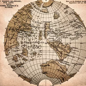
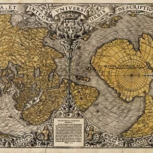
Oronce Fines world map, 1531
Oronce Fines world map. Map of the worlds northern and southern hemispheres by the French mathematician and cartographer Oronce Fine (1494-1555). Published in 1531 as A New and Complete Description of the World, this is a double polar cordiform (heart-shaped) projection. It shows an unknown southern continent, Terra Australis, and excludes most of the Americas. The text box names the publisher (Hermannus Venraed), gives Fines Latin name (Orontius Fineus), and mentions the Ancient Greek geographers (Ptolemy, Eudoxus, and Erastothenes), whose accounts Fine had tried to reconcile with the new discoveries being made
Science Photo Library features Science and Medical images including photos and illustrations
Media ID 6297693
© LIBRARY OF CONGRESS, GEOGRAPHY AND MAP DIVISION/SCIENCE PHOTO LIBRARY
1500s 16th Century Africa African Age Of Discovery Antarctic Arctic Cartographic Cartography Continent Continental Continents French Global Heart Shaped Latin Mediaeval Medieval Middle Ages North Pole Northern Hemisphere Polar Projection Ptolemy South Pole Southern Hemisphere Text World World Wide Writing 1531 Oronce Fine Terra Australis
Jigsaw Puzzle (1000 Pieces)
Discover the wonders of the world with Media Storehouse's Jigsaw Puzzles, featuring the intricately detailed and historically significant "Oronce Fines World Map, 1531." This captivating puzzle showcases an exquisite representation of the world as it was known during the Renaissance period by the renowned French mathematician and cartographer, Oronce Fine. Immerse yourself in the beauty of this intricately designed map, as you piece together the northern and southern hemispheres and explore the unknown territories of a bygone era. Perfect for history enthusiasts, puzzle lovers, or anyone seeking a challenging and rewarding pastime, this jigsaw puzzle is a must-have addition to your collection. Bring the past to life, one piece at a time.
1000 piece puzzles are custom made in Australia and hand-finished on 100% recycled 1.6mm thick laminated puzzle boards. There is a level of repetition in jigsaw shapes with each matching piece away from its pair. The completed puzzle measures 76x50cm and is delivered packaged in an attractive presentation box specially designed to fit most mail slots with a unique magnetic lid
Jigsaw Puzzles are an ideal gift for any occasion
Estimated Product Size is 76cm x 50.2cm (29.9" x 19.8")
These are individually made so all sizes are approximate
Artwork printed orientated as per the preview above, with landscape (horizontal) or portrait (vertical) orientation to match the source image.
FEATURES IN THESE COLLECTIONS
> Africa
> Related Images
> Africa
> South Africa
> Maps
> Africa
> South Africa
> Related Images
> Animals
> Mammals
> Cricetidae
> Australis
> Animals
> Mammals
> Delphinidae
> Australis
> Animals
> Mammals
> Molossidae
> Australis
> Arts
> Art Movements
> Medieval Art
> Asia
> Related Images
> Maps and Charts
> Popular Maps
EDITORS COMMENTS
This print showcases Oronce Fine's remarkable world map from 1531. Created by the French mathematician and cartographer, this intricate piece titled "A New and Complete Description of the World" offers a unique perspective on Earth's northern and southern hemispheres. The map is presented in a double polar cordiform (heart-shaped) projection, adding an artistic touch to its scientific accuracy. Fine's masterpiece reveals both familiar and unfamiliar elements of our planet. While it accurately depicts Africa, Asia, Europe, and parts of the Arctic region, it intriguingly includes an unknown southern continent called Terra Australis. Notably absent are most of the Americas, highlighting the limited knowledge about these lands during that era. The accompanying text box provides valuable information about this historical artifact. It mentions Hermannus Venraed as the publisher while sharing Fine's Latin name: Orontius Fineus. Additionally, it acknowledges ancient Greek geographers such as Ptolemy, Eudoxus, and Erastothenes whose accounts influenced Fine's work as he sought to reconcile their teachings with new discoveries. This photograph not only captures a significant moment in cartographic history but also serves as a testament to humanity's thirst for knowledge during the Age of Discovery. With its meticulous details and rich symbolism represented through artistry and science alike, this image invites us to reflect upon our ever-evolving understanding of our vast world throughout different periods in time.
MADE IN AUSTRALIA
Safe Shipping with 30 Day Money Back Guarantee
FREE PERSONALISATION*
We are proud to offer a range of customisation features including Personalised Captions, Color Filters and Picture Zoom Tools
SECURE PAYMENTS
We happily accept a wide range of payment options so you can pay for the things you need in the way that is most convenient for you
* Options may vary by product and licensing agreement. Zoomed Pictures can be adjusted in the Cart.